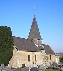
Étouvy facts for kids
Quick facts for kids
Étouvy
|
|
|---|---|
|
Part of Souleuvre-en-Bocage
|
|

St. Martin
|
|
| Country | France |
| Region | Normandy |
| Department | Calvados |
| Arrondissement | Vire |
| Canton | Condé-en-Normandie |
| Commune | Souleuvre-en-Bocage |
| Area
1
|
2.29 km2 (0.88 sq mi) |
| Population
(2019)
|
283 |
| • Density | 123.6/km2 (320.1/sq mi) |
| Time zone | UTC+01:00 (CET) |
| • Summer (DST) | UTC+02:00 (CEST) |
| Postal code |
14350
|
| Elevation | 82–134 m (269–440 ft) (avg. 120 m or 390 ft) |
| 1 French Land Register data, which excludes lakes, ponds, glaciers > 1 km2 (0.386 sq mi or 247 acres) and river estuaries. | |
Étouvy was a small commune (a type of town or district) located in the Calvados area of Normandy, a region in northwestern France. It was known for its quiet, rural setting.
On January 1, 2016, Étouvy joined with several other communes to form a new, larger commune called Souleuvre-en-Bocage. This means Étouvy is no longer a separate commune on its own.
Where is Étouvy?
Étouvy is located in the Normandy region of France. This area is known for its green landscapes and rich history. The village is about 120 meters (around 394 feet) above sea level. Its lowest point is 82 meters, and its highest point is 134 meters. The total area of Étouvy was about 2.29 square kilometers (less than one square mile).
How Many People Lived There?
The number of people living in Étouvy changed over the years. This is called its population. In 2019, about 283 people lived there.
Here is how the population of Étouvy changed over time:
| Historical population | ||
|---|---|---|
| Year | Pop. | ±% |
| 1962 | 122 | — |
| 1968 | 136 | +11.5% |
| 1975 | 152 | +11.8% |
| 1982 | 198 | +30.3% |
| 1990 | 227 | +14.6% |
| 1999 | 279 | +22.9% |
| 2008 | 306 | +9.7% |
As you can see, the population generally grew from 1962 to 2008. This shows that more people moved to Étouvy over those years.
See also
 In Spanish: Étouvy para niños
 | James B. Knighten |
 | Azellia White |
 | Willa Brown |


