
Évaillé facts for kids
Quick facts for kids
Évaillé
|
|
|---|---|

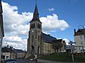
The church of Saint Martin
|
|

Évaillé
Location in France

Évaillé
Location in Pays de la Loire
|
|
| Country | France |
| Region | Pays de la Loire |
| Department | Sarthe |
| Arrondissement | Mamers |
| Canton | Saint-Calais |
| Intercommunality | Communauté de communes du Pays Calaisien |
| Area
1
|
19.43 km2 (7.50 sq mi) |
| Population
(2006)
|
365 |
| • Density | 18.785/km2 (48.65/sq mi) |
| Demonym(s) | Evaillléen, Evailléenne |
| Time zone | UTC+01:00 (CET) |
| • Summer (DST) | UTC+02:00 (CEST) |
| INSEE/Postal code |
72128 /72120
|
| Elevation | 106–167 m (348–548 ft) |
| 1 French Land Register data, which excludes lakes, ponds, glaciers > 1 km2 (0.386 sq mi or 247 acres) and river estuaries. | |
Évaillé was a small town, also known as a commune, located in the western part of France. It was found in the Pays de la Loire region, within the Sarthe department.
On January 1, 2019, Évaillé joined with other nearby towns to form a new, larger commune called Val-d'Étangson. This means Évaillé is no longer a separate commune on its own.
Contents
What Was Évaillé Like?
Évaillé was a quiet place with a small population. In 2006, about 365 people lived there. The people from Évaillé were called Evailléen (for men) or Evailléenne (for women).
Where Was Évaillé Located?
Évaillé was in the Sarthe department. This department is known for its green landscapes and charming villages. The town was part of the Mamers arrondissement and the Saint-Calais canton.
How Was Évaillé Governed?
Like all French communes, Évaillé had a mayor who was in charge. The mayor helped manage the town's daily life. From 2008 to 2014, the mayor of Évaillé was Guy Leproux.
What is a Commune?
A commune is the smallest type of administrative area in France. Think of it like a local town or village. Each commune has its own local government and mayor.
What is Intercommunality?
Évaillé was part of a group of communes called the Communauté de communes du Pays Calaisien. This is a way for several small towns to work together. They share resources and services, like waste collection or public transport. This helps them manage things more efficiently.
Geography of Évaillé
Évaillé covered an area of about 19.43 square kilometers (about 7.5 square miles). The land in Évaillé was not completely flat.
How High Was Évaillé?
The lowest point in Évaillé was 106 meters (about 348 feet) above sea level. The highest point reached 167 meters (about 548 feet). This shows that the area had some gentle hills.
Images for kids
-
The church of Saint Martin
See also

