
2019 Pacific typhoon season facts for kids
The 2019 Pacific typhoon season was a very active and expensive year for storms in the Pacific Ocean. These storms, called typhoons, form over the ocean and can bring strong winds and heavy rain to countries around the Pacific. This season was the most costly on record, causing a lot of damage.

Storms Throughout the Year
Early Months: January, February, March
The year started busy! In January, Tropical Storm Pabuk (2019) formed. It was the earliest tropical storm ever recorded in the Western Pacific. Pabuk caused floods and led to 10 deaths in Mindanao, Philippines.
February was also active. Tropical Storm Wutip grew into the season's first typhoon. It then became the first Category 5 super typhoon of the season. This was earlier than usual for such a strong storm. Wutip caused some damage to the Micronesia Islands. People wondered if its strength was normal or linked to climate change.
March was quiet, with only one tropical depression, Chedeng. It brought some rain to Mindanao before fading away.
Spring: April and May
April had no storms at all. In May, four small tropical depressions formed, but they didn't get very strong and disappeared quickly.
Summer: June and July
June began with Tropical Depression Dodong, which became Tropical Storm Sepat. This storm moved towards Japan. Another storm, Egay, formed and brought rain to the Philippines.
July was also fairly quiet, with no typhoons. Tropical Storm Mun formed and hit Hainan, China, causing minor damage. Later, Tropical Storm Danas caused confusion among weather experts because it moved strangely. Its clouds split, and one part became Tropical Depression Goring, which affected Taiwan. Goring's remnants then helped form Tropical Storm Nari, which headed for Japan. Tropical Storm Wipha also formed in the South China Sea, causing little damage in China.
Busy August
August was when the season really picked up! Tropical Storm Francisco slowly grew into a typhoon. At the same time, Tropical Storm Lekima formed and quickly became the season's second super typhoon. Lekima hit China and became the second most expensive storm in China's history. Another typhoon, Krosa, also formed and moved erratically through Japan.
Later in August, Tropical Storm Bailu formed. It caused heavy rains and floods in the Ilocos Norte region of the Philippines, leading to about 1 billion Philippine pesos in damage. Bailu also hit Taiwan and China, causing more damage. Tropical Storm Podul formed at the end of August and caused most of its damage in Vietnam.
September's Powerful Storms
September began with three tropical depressions forming on the same day. Tropical Storm Kajiki caused flooding in Vietnam and the Philippines. Tropical Storm Lingling became a typhoon and was the strongest storm to hit North Korea. Typhoon Faxai was another powerful storm, hitting Tokyo as the strongest storm there in 60 years.
In mid-September, Tropical Depression Marilyn and Tropical Storm Peipah interacted. This led to Tropical Storm Tapah, which later became a typhoon and hit Japan. Close behind Tapah was Typhoon Mitag, which also struck similar areas in Japan.
October's Major Impact

October saw the formation of Tropical Storm Hagibis. It quickly became a super typhoon with a very clear "pinhole eye" (the calm center of the storm). Hagibis passed over the Mariana Islands at its strongest. It later weakened but still hit Japan as a strong typhoon. Many sports events, including a Formula 1 race, were canceled. The flooding in Japan was very serious, and the storm cost an estimated 15 billion US dollars.
Three other tropical cyclones formed in October:
- Neoguri hit southern Japan.
- Bualoi stayed mostly over the ocean.
- Matmo hit Vietnam, bringing heavy rain. Its leftover energy helped form an Indian Ocean cyclone called Bulbul.
November's Strongest Storm
November had six named storms. The most intense storm of the entire season, Typhoon Halong, formed on November 1. It became a Category 5 super typhoon with very strong winds.
Later in November, Kammuri formed. It became a Category 4 typhoon and made landfall in the Philippines on November 30. Kammuri caused 12 deaths and about $116 million in damage.
December's Final Storm
December was quieter. The last named storm of the season, Phanfone, formed on December 19. Phanfone hit the Philippines on December 25, Christmas Day, as a Category 2 typhoon. This was the first time a typhoon hit the Philippines on Christmas since 2016. Phanfone caused 50 deaths and $61.7 million in damage before it disappeared on December 29.
Overall, the 2019 Pacific typhoon season had more storms than average, with 29 named storms. It was also the most expensive typhoon season ever recorded.
How Storms Get Their Names
Storms in the Northwest Pacific Ocean get names from two main groups: the Japan Meteorological Agency (JMA) and the Philippine Atmospheric, Geophysical and Astronomical Services Administration (PAGASA). This means a storm can sometimes have two names!
The JMA gives international names to tropical cyclones when their winds reach a certain speed (65 km/h or 40 mph). They use a list of 140 names chosen by 14 different countries and territories.
PAGASA gives its own names to storms that enter or form in their special area near the Philippines. They have their own list of names. If a storm causes a lot of damage, its name might be "retired" and not used again.
International Names
Here are the international names used for storms in 2019. The number in brackets is the storm's official number for the year. The name "Mun" was used for the first time this season, replacing an old name called "Fitow."
|
|
|
|
Philippine Names
PAGASA uses its own list of names for storms in its area. These names were last used in 2015 and will be used again in 2023. Two names, Liwayway and Nimfa, were new for this season, replacing older names that had been retired.
|
|
|
|
|
| Extra Names (Auxiliary list) | ||||
|---|---|---|---|---|
|
|
|
|
|
Images for kids
-
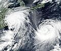
Typhoons Lekima (left) and Krosa (right) on August 9, 2019.
-
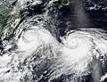
On August 8, 2019, two named storms were active at the same time: Lekima (left) and Krosa (right).
-
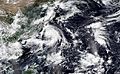
On September 5, 2019, three storms were active at the same time: Kajiki (left), Lingling (center), and Faxai (right).


See also
 In Spanish: Temporada de tifones en el Pacífico de 2019 para niños
