Aïn Defla Province facts for kids
Quick facts for kids
Aïn Defla Province
ولاية عين الدفلى
|
|
|---|---|

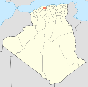
Map of Algeria highlighting Aïn Defla
|
|
| Country | |
| Capital | Aïn Defla |
| Area | |
| • Total | 4,897 km2 (1,891 sq mi) |
| Population
(2008)
|
|
| • Total | 771,890 |
| • Density | 157.625/km2 (408.25/sq mi) |
| Time zone | UTC+01 (CET) |
| Area Code | +213 (0) 27 |
| ISO 3166 code | DZ-44 |
| Districts | 14 |
| Municipalities | 36 |
Aïn Defla is a special area, like a state or region, in the northern part of Algeria. It's located southwest of Algiers, which is the capital city of Algeria. This province is home to several interesting towns, including Miliana, Hammam Righa, and Aïn Torki.
Contents
About Aïn Defla Province
Aïn Defla Province is a part of Algeria. It is known for its beautiful landscapes. The province covers an area of about 4,897 square kilometers. This is roughly the size of a small country.
Population and People
In 2008, about 771,890 people lived in Aïn Defla Province. The people here contribute to the rich culture of Algeria.
Government and Leadership
Each province in Algeria has its own leaders. The main leader of Aïn Defla Province is called the Wāli. Think of a Wāli as a governor. The current Wāli is Mr. Tikhmarine Lakhdar. There is also a president of the People's Provincial Assembly (PPA). This assembly helps make decisions for the province. The current PPA president is Mr. Menad Mehdi.
How Aïn Defla is Organized
Aïn Defla Province is divided into smaller parts. This helps manage the area better. It has 14 main sections called districts. Within these districts, there are even smaller areas called municipalities. There are 36 municipalities in total.
Districts of Aïn Defla
Here are the 14 districts that make up Aïn Defla Province:
- Aïn Defla
- Aïn Lechiakh
- Bathia
- Bordj El Amir Khaled
- Boumedfaâ
- Djendel
- Djelida
- El Abadia
- El Amra
- El Attaf
- Hammam Righa
- Khemis
- Miliana
- Rouina
See also
 In Spanish: Provincia de Aín Defla para niños
 | Delilah Pierce |
 | Gordon Parks |
 | Augusta Savage |
 | Charles Ethan Porter |

