Aïn Témouchent Province facts for kids
Quick facts for kids
Aïn Témouchent Province
ولاية عين تموشنت
|
|
|---|---|

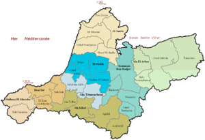
Administrative map of Aïn Témouchent province
|
|

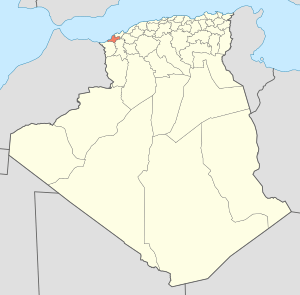
Map of Algeria highlighting Aïn Témouchent
|
|
| Country | |
| Capital | Aïn Témouchent |
| Area | |
| • Total | 2,376.89 km2 (917.72 sq mi) |
| Population
(2010)
|
|
| • Total | 384,565 |
| • Density | 161.7934/km2 (419.0429/sq mi) |
| Time zone | UTC+01 (CET) |
| Area Code | +213 (0) 27 |
| ISO 3166 code | DZ-46 |
| Districts | 8 |
| Municipalities | 28 |
Aïn Témouchent is a province located in the northwestern part of Algeria. A province is like a large region or state within a country. The main city and capital of this province is also called Aïn Témouchent.
About Aïn Témouchent Province
This province is a vibrant area in Algeria. It covers about 2,377 square kilometers. In 2010, around 384,565 people lived here. The province is known for its beautiful landscapes and important role in the region.
How is it Governed?
Aïn Témouchent Province is divided into smaller areas to help manage it. It has 8 main areas called districts. Within these districts, there are 28 even smaller areas called municipalities.
The province has leaders who help run things. The president of the People's Provincial Assembly (PPA) is Mr. Tikhmarine Lakhdar. The Wali, who is like a governor, is Mr. Bouderbali Mohamed. They work to make sure the province runs smoothly for its residents.
What are the Districts?
The 8 districts that make up Aïn Témouchent Province are:
- Aïn Kihel
- Aïn Larbaâ
- Aïn Témouchent
- Béni Saf
- El Amria
- El Malah
- Hammam Bou Hadjar
- Oulhassa Gheraba
See also
 In Spanish: Provincia de Aín Temushent para niños
 | Aaron Henry |
 | T. R. M. Howard |
 | Jesse Jackson |

