A Rúa facts for kids
Quick facts for kids
A Rúa
|
||
|---|---|---|
|
||
 |
||
| Country | ||
| Autonomous community | ||
| Province | ||
| Comarca | Valdeorras | |
| Area | ||
| • Total | 35.9 km2 (13.9 sq mi) | |
| Elevation | 317 m (1,040 ft) | |
| Population
(2018)
|
||
| • Total | 4,359 | |
| • Density | 121.42/km2 (314.5/sq mi) | |
| Time zone | UTC+1 (CET) | |
| • Summer (DST) | UTC+2 (CEST) | |
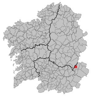
A Rúa is a town in Spain, mostly surrounded by countryside. It's located in the Ourense province, which is part of Galicia, a region in northwest Spain. It's also part of an area called Valdeorras. The main city of the province, Ourense, is about 101 kilometers (63 miles) away. People from A Rúa are called rueses.
A Rúa has three smaller areas within it, called parroquias: A Rúa de Valdeorras, Roblido, and San Xulián.
Contents
Exploring A Rúa's Location
The town of A Rúa is surrounded by other places. To the north, you'll find lugués de Quiroga. To the east, it borders Vilamartín de Valdeorras. A Rúa is located on the northern edge of the Valdeorras valley.
Mountains and Rivers in A Rúa
The Cereixido hills are in the northern part of the town. The highest point there is Cabeza Porriñas, which is 1,221 meters (about 4,006 feet) tall. The Sil river forms the southern border of the town.
A Rúa's Climate and Nature
A Rúa has a warm, Mediterranean-like climate. It doesn't get much rain, and summers are usually dry. This special weather and the type of land make the area perfect for growing grapes. This is why viticulture, or winemaking, is very important here.
A Rúa Through History
Long ago, even before the Romans arrived, a group of people called the Cigurri tribe lived in A Rúa and the Valdeorras area. These people were part of the Asturian group and spoke a Celtic language. The name Valdeorras actually means "valley of the Cigurri."
The Roman Era in A Rúa
The Romans, led by Emperor Augustus, came to this region around 25 BC. There were some wars, but eventually, the Romans took control. Near A Rúa, there was an important Roman center called Forum Cigurrorum. This was a political hub located on a major Roman road that connected two big cities.
A Rúa in the Middle Ages
After the Romans, different groups ruled the area, like the Suebic Kingdom and then the Visigothic Kingdom. A Rúa was even home to a mint (a place where coins are made) for a short time.
Later, in the 8th century, King Alfonso I of Asturias took the region back from Muslim rule. He created a "buffer zone" to protect his kingdom, which meant many people moved away from Valdeorras. But later, people started to move back and settle the area again. During the Middle Ages, A Rúa was known as San Esteban de La Rúa and was the main town of Valdeorras. Over time, it was part of different kingdoms, including Asturias, Galicia, León, and Castile.
Modern Times in A Rúa
During the Spanish War of Independence in the early 1800s, Spanish fighters and Napoleon's army had battles in this region. In 1833, Spain's administrative areas changed. Valdeorras, including A Rúa, became part of Galicia.
A very important event for the town's economy was the opening of the railway line in 1883. This train line connected A Rúa to bigger cities and helped the region grow.
A Rúa's Economy
For a very long time, Valdeorras has been known for making wine. This is because of its good climate and its location near the Sil river. Today, making wines and other alcoholic drinks is still the main way people in A Rúa earn money. The town is strongly connected to wine, and you'll see many wine cellars here. In 2011, a famous wine expert, Robert M. Parker, even said that wines from Valdeorras were among the best in the world!
Other Jobs in A Rúa
While there isn't much mining directly in A Rúa, many people who live here work in slate mines in nearby towns. Slate is a type of rock used for roofing and other building materials.
Besides wine and slate, other important jobs in A Rúa include making electricity, carpentry (working with wood), transporting goods, and working in hotels and restaurants. There's also a new factory and businesses related to the car industry.
Natural and Historic Treasures of A Rúa
A Rúa has many interesting places to visit, both natural and historical.
- Cigarrosa Bridge: This is an old Roman bridge that crosses the Sil river. Near the bridge, archaeologists found the remains of a Roman villa (a large house) with baths. The bridge connects A Rúa with the town of Petín and is now only for people walking.
- Santo Estevo da Rúa Church: This church was built in the 16th century (the 1500s). It's one of the most impressive old churches in the region.
- Reservoir of Saint Martin River Area: Along the banks of the Sil river, there's a beautiful natural area with lots of plants and animals. There's also a riverside path with tall poplar trees, and a place for sports and fun activities.
- Camino de Invierno: A Rúa is on a special path that is part of the famous Camino de Santiago (Way of St. James). This path is called the "Winter Way" because it offered a way to avoid difficult mountain climbs during winter.
See also
 In Spanish: Rúa para niños
 | Bessie Coleman |
 | Spann Watson |
 | Jill E. Brown |
 | Sherman W. White |


