Abadia dos Dourados facts for kids
Quick facts for kids
Abadia dos Dourados
|
|||
|---|---|---|---|
|
Municipality
|
|||
|
|||
|
|||

Location in Minas Gerais
|
|||
| Country | |||
| Region | Southeast | ||
| State | |||
| Founded | December 27, 1948 | ||
| Area | |||
| • Total | 881.064 km2 (340.181 sq mi) | ||
| Population
(2020)
|
|||
| • Total | 7,006 | ||
| • Density | 7.61/km2 (19.7/sq mi) | ||
| Demonym(s) | abadiense | ||
| Time zone | UTC−3 (BRT) | ||
| Postal code |
38540-000 to 38549-999
|
||
| Area code(s) | (+55) 34 | ||
| Website | www.abadiadosdourados.mg.gov.br | ||
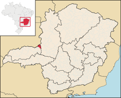
Abadia dos Dourados is a town in Brazil. It is located in the northwest part of the Minas Gerais state. In 2020, about 7,006 people lived there. The town covers an area of 894 square kilometers.
Abadia dos Dourados is part of the mesoregion called Triângulo Mineiro e Alto Paranaiba. It is also in the microregion of Patrocínio. The town officially became a municipality in 1948.
Contents
Where is Abadia dos Dourados?
The town is in a region known as Alto Paranaíba. It is south of the Paranaíba River. It is also west of the Emborcação Reservoir. The town sits in the valley of the Dourados River.
Nearby Towns
Abadia dos Dourados has several neighboring towns. These include:
- Catalão to the North
- Monte Carmelo to the South
- Coromandel to the East
- Douradoquara to the West
How Far is It?
Here are some distances from Abadia dos Dourados to other cities:
- Coromandel: 23 kilometers
- Monte Carmelo: 33 kilometers
- Patrocínio: 71 kilometers
- Uberlândia: 135 kilometers
- Belo Horizonte: 547 kilometers (Belo Horizonte is the capital city of Minas Gerais state)
History of Abadia dos Dourados
The first European settlers arrived in this area in the 1800s. They were looking for diamonds. The first church was built in 1886.
The town was first called Arraiai do Garimpo. This means "Village of the Mining Claim." Later, its name changed. The church was named Nossa Senhora da Abadia. The town was also close to the Dourados River. These two things gave the town its current name: Abadia dos Dourados.
In 1882, it became a district of Patrocínio. In 1923, it joined the municipality of Coromandel. Finally, in 1948, it became its own separate municipality.
What People Do for a Living
The main ways people earn money in Abadia dos Dourados are:
- Raising cattle (livestock farming)
- Running shops and businesses (commerce)
- Farming (agriculture)
In 2005, the total value of goods and services produced in the town (called GDP) was R$42 million. Most of this came from services (R$19 million). Agriculture brought in R$17 million. Industry added R$4 million.
Abadia dos Dourados is considered one of the better places in the state for its economy and social progress. In 2007, there was one bank in the town. There were also small shops that served the local farmers and cattle ranchers. In 2007, there were 995 cars in the whole municipality. This means there was about one car for every 7 people.
Farming and Livestock
Abadia dos Dourados has a small area for farming. In 2006, there were 910 farms. These farms covered about 71,000 hectares of land. About 6,800 hectares were used for planting crops. Another 52,000 hectares were natural pastures for animals.
Around 2,800 people worked in agriculture. About 100 of the farms had tractors. This means about 1 out of every 9 farms had a tractor. In 2006, there were 50,000 cattle in the area. The main crops grown were coffee, corn, rice, and soybeans.
See also
 In Spanish: Abadia dos Dourados para niños


