
Uberlândia facts for kids
Quick facts for kids
Uberlândia
|
||
|---|---|---|
|
Municipality
|
||
| Municipality of Uberlândia | ||
|
|
||
|
||
| Nickname(s):
"Udi", "The Logistical Capital"
|
||

Location in Minas Gerais
|
||

Uberlândia
Location in Brazil
|
||
| Country | ||
| State | ||
| Region | Southeast | |
| Intermediate Region | Uberlândia | |
| Immediate Region | Uberlândia | |
| Founded | 31 August 1888 | |
| Area | ||
| • Total | 4,115.9 km2 (1,589.2 sq mi) | |
| Elevation | 863 m (2,831 ft) | |
| Population
(2022)
|
||
| • Total | 713,224 | |
| • Density | 173.2851/km2 (448.806/sq mi) | |
| Demonym(s) | Uberlandense | |
| Time zone | UTC−3 (BRT) | |
| Postal Code (CEP) |
38400-000
|
|
| Area code(s) | +55 34 | |
| HDI (2010) | 0.789 – high | |


_Uberl%C3%A2ndia-MG_-_panoramio.jpg)

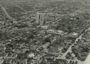
Uberlândia (pronounced oo-ber-LAN-jee-uh) is a big city in the state of Minas Gerais, located in southeastern Brazil. It is the second largest city in Minas Gerais, after the state capital, Belo Horizonte. In 2020, about 699,097 people lived there. This makes it the sixth largest city in the inner parts of Brazil.
The city is located on the Brazilian Highlands, about 854 meters (2,802 feet) above sea level. It is a very important place for moving goods between São Paulo and Brasília. Uberlândia is also part of the Brazilian cerrado, which is a type of tropical savanna. The city has eight special areas that protect this unique plant life.
You can fly to Uberlândia through the Uberlândia–Ten. Cel. Av. César Bombonato Airport.

Contents
Exploring Uberlândia's Location and Connections
Uberlândia is in the western part of Minas Gerais. This area is called Triângulo Mineiro, which is one of Brazil's richest farming regions. It sits between the Paranaíba and Grande rivers. The city is well-connected to other major cities by important highways.
For example, Uberlândia is about 580 kilometers (360 miles) from São Paulo. A modern highway, BR-050, connects them. The state capital, Belo Horizonte, is 560 kilometers (348 miles) away. Brasília, the capital of Brazil, is only 440 kilometers (273 miles) to the north. There are also railways that connect Uberlândia to other places.
Because of its great location and transport links, Uberlândia was chosen as a distribution point for the Free Economic Zone of Manaus. This was the first time such a point was set up outside Manaus.

Understanding Beliefs in Uberlândia
In 2010, a survey showed that most people in Uberlândia (54.73%) were members of the Roman Catholic Church. The second largest group (25.23%) were Evangelical Christians. There were also smaller groups of Spiritists (7.80%) and people who said they had no religion (7.80%). Other religions, like Islam and Buddhism, also have followers in the city, but in smaller numbers.
Discovering Fun Places in Uberlândia
Uberlândia has many interesting places to visit, from old buildings to beautiful natural spots. Here are some of the main attractions:
Municipal Market of Uberlândia
This market is in the city center. It started in 1923 and was built with a modern design. It used to be a place where goods were sold in large amounts. Today, it offers many local products from Minas Gerais. You can find it on Olegario Máciel Road.
Municipal Museum of Uberlândia
Also in the city center, this museum is on Clarimundo Carneiro Square. The building used to be the City Hall. Now, it has been updated and hosts many cultural events and projects.
Sabiá Park: A Green Oasis
This large park and zoo is managed by FUTEL, which is Uberlândia's foundation for tourism, sport, and fun. It is located in the Tibery area. The park has:
- A zoo with many different animals.
- Seven lakes that connect to form one big lagoon.
- An aquarium with 36 tanks and 36 different kinds of fish.
- A long running track, perfect for exercise.
Municipal Park Victoria Siquierolli: Nature's Beauty
This park is in the northern part of Uberlândia. It is a great place to see real examples of the Brazilian cerrado plants. You can find trees with tough leaves, twisted trunks, colorful flowers, and many fruits. The park also has a playground for kids and a museum about biodiversity. It covers a large area of 232,300 square meters.
Rondon Pacheco Avenue: The Foodie Street
This avenue is known as Uberlândia's "food corridor." It is where you can find much of the city's nightlife. There are many bars, restaurants, pizzerias, cafes, and ice cream shops. More than 60 different places to eat and drink are located along this avenue. You will also find hotels, supermarkets, and gas stations here. The avenue goes from the east to the west side of the city.
Uberlândia's Weather
| Climate data for Uberlândia (1981–2010) | |||||||||||||
|---|---|---|---|---|---|---|---|---|---|---|---|---|---|
| Month | Jan | Feb | Mar | Apr | May | Jun | Jul | Aug | Sep | Oct | Nov | Dec | Year |
| Mean daily maximum °C (°F) | 29.4 (84.9) |
29.9 (85.8) |
29.5 (85.1) |
29.2 (84.6) |
27.5 (81.5) |
26.8 (80.2) |
27.0 (80.6) |
29.3 (84.7) |
30.6 (87.1) |
30.8 (87.4) |
29.6 (85.3) |
29.1 (84.4) |
29.1 (84.4) |
| Daily mean °C (°F) | 23.6 (74.5) |
23.7 (74.7) |
23.4 (74.1) |
22.8 (73.0) |
20.6 (69.1) |
19.3 (66.7) |
19.2 (66.6) |
21.2 (70.2) |
23.2 (73.8) |
23.8 (74.8) |
23.5 (74.3) |
23.2 (73.8) |
22.3 (72.1) |
| Mean daily minimum °C (°F) | 19.6 (67.3) |
19.5 (67.1) |
19.4 (66.9) |
18.2 (64.8) |
15.7 (60.3) |
14.3 (57.7) |
13.9 (57.0) |
15.3 (59.5) |
17.5 (63.5) |
18.7 (65.7) |
19.1 (66.4) |
19.2 (66.6) |
17.5 (63.5) |
| Average precipitation mm (inches) | 299.0 (11.77) |
201.8 (7.94) |
225.5 (8.88) |
83.1 (3.27) |
33.9 (1.33) |
19.2 (0.76) |
7.8 (0.31) |
15.3 (0.60) |
46.4 (1.83) |
116.3 (4.58) |
215.1 (8.47) |
342.7 (13.49) |
1,606.1 (63.23) |
| Average precipitation days (≥ 1.0 mm) | 17 | 15 | 14 | 7 | 3 | 1 | 1 | 2 | 5 | 9 | 13 | 19 | 106 |
| Average relative humidity (%) | 78.8 | 77.2 | 78.9 | 73.9 | 70.9 | 68.1 | 61.9 | 56.3 | 58.7 | 66.9 | 74.0 | 79.5 | 70.4 |
| Mean monthly sunshine hours | 167.5 | 167.5 | 171.2 | 211.7 | 223.2 | 223.6 | 243.9 | 243.3 | 203.7 | 195.4 | 176.8 | 145.2 | 2,373 |
| Source: Instituto Nacional de Meteorologia | |||||||||||||
See also
 In Spanish: Uberlândia para niños
