Brazilian Highlands facts for kids
Quick facts for kids Brazilian Highlands |
|
|---|---|

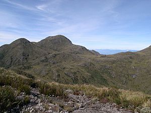
Pedra da Mina, a mountain in the state of São Paulo, in 1997
|
|

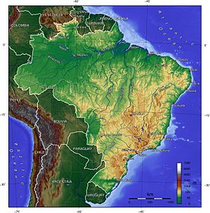
Topographic map of Brazil. The Brazilian Highlands/Plateau is the large yellowish and brown area in the east, south and center of the country.
|
|
| Location | Caatinga and Cerrado, Brazil |
| Highest point – elevation – coordinates |
Pico da Bandeira 2,891 m (9,485 ft) 22°28′S 45°00′W / 22.467°S 45.000°W |
| Length | 3,500 km (2,200 mi), SW x NE |
| Area | 5,000,000 km2 (1,900,000 sq mi) |
| Geology | Plateau |
The Brazilian Highlands or Brazilian Plateau (in Portuguese: Planalto Brasileiro) is a huge natural area. It covers much of eastern, southern, and central Brazil. This region is about 4,500,000 square kilometers (1,700,000 sq mi). That's roughly half of Brazil's total land.
Most of Brazil's people live in these highlands. They also live on the narrow strip of land along the coast next to it.
Long ago, ancient lava flows helped create much of this region. These flows were made of a rock called basalt. Today, there are no earthquakes or volcanoes here. So, the land is very stable.
Erosion has also played a big part in shaping the Highlands. Erosion is when wind and water wear away rocks and soil. This process has formed many sediment deposits. It has also worn down the mountains over time.
The Brazilian Highlands are known for their amazing variety. Inside this region, you can find many different biomes. A biome is a large natural area with certain plants and animals. There are also many different climates and types of soil. Thousands of animal and plant species live here.
Main Parts of the Brazilian Highlands
Because the Brazilian Highlands are so big and diverse, they are split into three main areas:
- Atlantic Plateau: This part stretches along Brazil's eastern coast. It includes several mountain ranges. This area was once covered by the Atlantic Forest. This forest was one of the richest places for different kinds of life on Earth. Sadly, only about 7.3% of it remains today.
- Southern Plateau: This area goes inland in the southern parts of Brazil. It has sedimentary rocks. These rocks are partly covered by basaltic lava spills. These spills form a very fertile soil known as "purple land." Much of this region was also covered by the Atlantic Forest. Other parts had araucaria highland forests and cerrado grasslands.
- Central Plateau: This part is in the middle of Brazil. It has both sedimentary and crystalline rock formations. About 85% of this area was once covered by cerrado plants. Only a small part of this original vegetation is still left.
Besides these plateau regions, several nearby mountain ranges are also part of the Brazilian Highlands. Some of the most important ones are (from north to south):
- Serra da Borborema
- Chapada Diamantina
- Serra do Espinhaço
- Serra do Caparaó
- Serra da Mantiqueira
- Serra do Mar
- Serra Geral
The highest point in the Brazilian Highlands is Pico da Bandeira. It is in the Serra do Caparaó. This peak is 2,891 meters (9,485 feet) tall.
See also
 In Spanish: Meseta brasileña para niños
- Guiana Shield
- Serras de Sudeste
 | Selma Burke |
 | Pauline Powell Burns |
 | Frederick J. Brown |
 | Robert Blackburn |

