Abadiânia facts for kids
| Abadiânia | |
|---|---|
| State | Goiás |
| Geographical coordinates: | 16°06′S 48°48′W / 16.100°S 48.800°W |
| Area: | 1,047 km² |
| Population: | 12,736 (IBGE 2005) |
| Elevation: | 1,052 m above sea level |
| Postal code (CEP): | 72940-000 |
| Became a city: | 1953 |
| Statistical Microregion: | Entorno do Distrito Federal |
| Distance to Goiânia: | 88 km. |
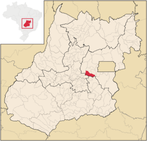
Abadiânia is a city found in the state of Goiás, Brazil. It is a place with a rich history and a growing community.
Where is Abadiânia?
Abadiânia is part of a special area called the Entorno do Distrito Federal. This area is close to Brazil's capital, Brasília.
The city has several neighbors:
- To the north: Pirenópolis, Corumbá de Goiás, and Alexânia
- To the south: Silvânia
- To the east: Anápolis
- To the west: Alexânia
A Look at History
Abadiânia officially became a municipality (a type of city or town) in 1953. However, the city you see today was not built in its first location.
In the 1960s, people living there were not happy with how hard it was to get around. So, they started building their homes along a main highway, about 18 kilometers away. This new spot is where the city of Abadiânia stands today.
Images for kids
See also
 In Spanish: Abadiânia para niños
Black History Month on Kiddle
African-American Astronauts:
 | Stephanie Wilson |
 | Charles Bolden |
 | Ronald McNair |
 | Frederick D. Gregory |

All content from Kiddle encyclopedia articles (including the article images and facts) can be freely used under Attribution-ShareAlike license, unless stated otherwise. Cite this article:
Abadiânia Facts for Kids. Kiddle Encyclopedia.


