
Abapó facts for kids
Quick facts for kids
Abapó
|
|
|---|---|
|
Town
|
|

Abapó
Location in Bolivia
|
|
| Country | |
| Department | Santa Cruz |
| Province | Cordillera |
| Elevation | 1,460 ft (450 m) |
| Population | |
| • Total | 3,140 |
| Time zone | UTC-4 (BOT) |
| Postal code |
07-0703-0100-1001
|
| Area code(s) | (+591) |
| Climate | Aw |
| Sources: Google Maps OSM | |
Abapó is a small town in the Santa Cruz Department of Bolivia. It's located near the eastern Andes mountains. The town sits on the north side of the Rio Grande. This river flows east and then north into the huge Amazon Basin. A railway and a main road cross the river right at Abapó.
Contents
What's the Weather Like in Abapó?
Abapó has a tropical climate. This means it has two main seasons. From November to April, it's humid and wet. From May to October, it's dry.
The average temperature all year is about 23 °C (73 °F). In June and July, it cools down a bit to 17-18 °C (63-64 °F). From November to December, it gets warmer, over 26 °C (79 °F).
The town gets about 800 mm (31 inches) of rain each year. January and February are the wettest months. They get around 130 mm (5 inches) of rain. July and August are the driest. They only get 10 to 20 mm (less than 1 inch) of rain.
| Climate data for Abapó, elevation 440 m (1,440 ft), (1977–2013) | |||||||||||||
|---|---|---|---|---|---|---|---|---|---|---|---|---|---|
| Month | Jan | Feb | Mar | Apr | May | Jun | Jul | Aug | Sep | Oct | Nov | Dec | Year |
| Mean daily maximum °C (°F) | 34.7 (94.5) |
34.3 (93.7) |
33.5 (92.3) |
32.3 (90.1) |
28.0 (82.4) |
26.6 (79.9) |
27.9 (82.2) |
31.9 (89.4) |
35.7 (96.3) |
35.6 (96.1) |
36.0 (96.8) |
36.0 (96.8) |
32.7 (90.9) |
| Daily mean °C (°F) | 29.3 (84.7) |
28.1 (82.6) |
27.3 (81.1) |
26.0 (78.8) |
22.2 (72.0) |
20.2 (68.4) |
20.6 (69.1) |
23.6 (74.5) |
27.4 (81.3) |
28.3 (82.9) |
28.7 (83.7) |
29.7 (85.5) |
26.0 (78.7) |
| Mean daily minimum °C (°F) | 23.9 (75.0) |
21.9 (71.4) |
21.2 (70.2) |
19.7 (67.5) |
16.5 (61.7) |
13.5 (56.3) |
13.3 (55.9) |
15.3 (59.5) |
19.1 (66.4) |
21.1 (70.0) |
21.4 (70.5) |
23.5 (74.3) |
19.2 (66.6) |
| Average precipitation mm (inches) | 149.3 (5.88) |
134.4 (5.29) |
108.3 (4.26) |
77.1 (3.04) |
58.2 (2.29) |
38.7 (1.52) |
17.7 (0.70) |
9.3 (0.37) |
24.9 (0.98) |
58.4 (2.30) |
91.0 (3.58) |
139.9 (5.51) |
907.2 (35.72) |
| Average precipitation days | 8.9 | 8.2 | 8.0 | 6.6 | 6.3 | 4.6 | 2.8 | 1.4 | 2.2 | 4.2 | 6.3 | 7.8 | 67.3 |
| Source: Servicio Nacional de Meteorología e Hidrología de Bolivia | |||||||||||||
How to Get to Abapó
Abapó is about 142 kilometers (88 miles) south of Santa Cruz. Santa Cruz is the capital city of the department.
Roads and Highways
You can reach Abapó by taking Ruta 9. This is a paved highway that goes south from Santa Cruz. It passes through a town called Cabezas. After Abapó, the highway continues for another 405 kilometers (252 miles). It goes through Ipitá and Villamontes. Finally, it reaches Yacuiba, which is on the border with Argentina.
Train Travel
Abapó is also a stop on the railway line. This train line connects Santa Cruz to Yacuiba. You can catch a passenger train from Abapó. Trains go both north and south. A trip to Santa Cruz takes about three hours. Going south to Yacuiba takes about twelve hours.
How Many People Live in Abapó?
The number of people living in Abapó has grown a lot. In the last twenty years, the population has more than tripled!
| Year | Population |
|---|---|
| 1992 | 731 |
| 2001 | 2 218 |
| 2012 | 2 386 |
Some people in this area still speak their native languages. In the nearby area of Municipio Cabezas, about 9% of people speak Quechua. Another 6.8% speak Guaraní.
Images for kids
-
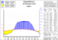
This chart shows the climate of Abapó.

See also
 In Spanish: Abapó para niños
