Abel Tasman Coast Track facts for kids
Quick facts for kids Abel Tasman Coast Track |
|
|---|---|

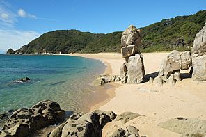
Anapai Bay, one of many beaches along the track
|
|
| Length | 60 km (37 mi) |
| Location | Abel Tasman National Park, New Zealand |
| Designation | New Zealand Great Walk |
| Trailheads | Marahau, Wainui Bay |
| Use | Tramping |
| Highest point | Saddle close to Wainui Bay 200 m (660 ft) |
| Lowest point | 0 m (0 ft) |
| Difficulty | Easy |
| Season | All year |
| Sights | Sandy beaches, lush coastal native bush, tidal estuaries and wetlands |
| Hazards | Tidal estuary crossings |
| Surface | Dirt, sand |
| Website | Department of Conservation |
The Abel Tasman Coast Track is a super cool walking path in Abel Tasman National Park, New Zealand. It's about 60 kilometres (37 mi) long! This track goes from Marahau in the south all the way to Wainui in the north. There are also lots of smaller paths you can explore.
This track is one of New Zealand's famous "Great Walks". It's really popular, with thousands of people visiting each year. You can walk it by yourself or join a guided tour. Many people also love to combine walking with sea kayaking along the beautiful coast.
The track is open all year round because the weather is usually mild. It's also well-protected from strong winds.
Contents
Exploring the Abel Tasman Coast Track
Walking the whole track usually takes 3 to 5 days. But you can also do shorter walks! Many spots along the track can be reached by boat. This means you can walk just a part of it for a day trip.
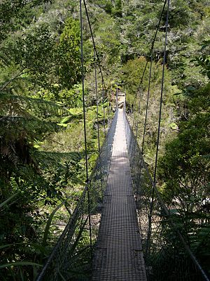
One popular short walk is from Bark Bay to Torrent Bay. It's about 7.8 kilometres long. This part has some steep paths and amazing views. You'll also cross the Falls River on a 47-meter long swing bridge!
Where to Stay Overnight
If you want to stay overnight, you need to use special places. You can book campsites or huts run by the Department of Conservation (DOC). Make sure to book ahead, especially during busy times! There are also some private lodges and even boats where you can stay.
Tidal Crossings
The track has some parts that cross tidal areas. These are places where the water level changes a lot with the tides. You can only cross these spots when the tide is low. It's important to know the tide times before you start your trip!
Sections of the Track
The Abel Tasman Coast Track is divided into different sections. These sections are named after the places where you can find huts to stay. You can also get to many points by water taxi. This makes it easy to walk just a part of the track.
Marahau to Anchorage Bay
Marahau is usually where people start their adventure. It's the only town right on the track. Here you'll find a DOC information center, small shops, and places to stay.
The first part of the track is 12.4 km long and leads to Anchorage Bay. You'll walk past the Marahau River estuary. An estuary is where a river meets the sea. You'll also see small bays and islands like Fisherman Island. Along the way, there are beaches and campsites at places like Apple Tree Bay.
Anchorage Bay has the biggest hut and campsite. It also has filtered drinking water. A fun side path from Anchorage leads to Cleopatra's Pool. This is a natural rock pool with a cool mossy waterslide!
Anchorage Bay to Bark Bay
Next, you'll reach Torrent Bay. Here, you'll cross one of the tidal estuaries. You can cross it when the tide is low. Or, you can take a longer path through the bush if the tide is high. This section is 8.4 km long and goes through coastal forest.
Bark Bay to Awaroa Inlet
This 13.5 km section goes through a forest of manuka trees. You won't see the sea much here. Bark Bay also has a tidal estuary. But there's a path that goes around it, so you don't have to wait for low tide.
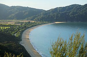
Halfway through this section, you'll reach Onetahuti Bay. It has a wide sandy beach and views of Tonga Island. You'll cross a bridge over Richardson Stream. Then, the track climbs gently to Awaroa Bay.
Awaroa Bay has a very wide tidal area called Awaroa Inlet. You can only cross it when the tide is low. There's a lodge, hut, and campsite here.
Awaroa Inlet to Whariwharangi Bay
This section is 16.9 km long. You can split it into two parts: 7.1 km to Totaranui and 9.8 km from there to Whariwharangi Bay Hut. There are also campsites at Waiharakeke Bay and Anapai Bay.
When you cross Awaroa Inlet, you'll walk across a wide sandy area. You might get your feet wet! A large orange triangle shows where the track continues on the other side. The Awaroa River flows through the middle. It's usually shallow, but can be deep after heavy rain.
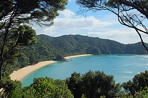
North of Awaroa Bay, the track crosses a small hill to Waiharakeke Bay. Then it goes into the forest and reaches Goat Bay. At both bays, you'll walk along sandy beaches. Between Goat Bay and Totaranui, the track climbs steeply. You'll get amazing views over Totaranui Bay from Skinner Point.
Totaranui is special because it's the only place you can drive to on the track, besides the start and end points. It has a big camping ground, car park, and toilets.
The track north of Totaranui is quieter but still very beautiful. You'll see the sandy beaches of Anapai Bay with cool rock formations. Then there's Anatakapau Bay and Mutton Cove.
Between Anatakapau Bay and Mutton Cove, the track turns towards Whariwharangi Bay. There's a side path that goes north to Separation Point. At Separation Point, you can see a lighthouse and a seal colony! Taking this side path adds about an hour to your walk.
Both paths lead to Whariwharangi Bay. Here, an old farm house has been turned into a DOC hut. There are also more campsites.
Whariwharangi Bay to Wainui Bay
This is the shortest section, only 5.7 km long. You'll climb out of Whariwharangi Bay and over a hill to Wainui Bay. The track follows the shoreline to a car park. You can cross the Wainui Inlet when the tide is low.
Mountain biking is not allowed on most of the Abel Tasman Coast Track. But from May to September, mountain bikers can ride on the Gibbs Hill track. The last 1 km of that track shares the coastal path.
Location
| Point | Coordinates (links to map & photo sources) |
Notes |
|---|---|---|
| Marahau | 40°59′45″S 173°00′18″E / 40.9958°S 173.0051°E | Small town, DOC office, car park |
| Anchorage | 40°57′24″S 173°03′26″E / 40.9568°S 173.0572°E | Hut & campsite |
| Torrent Bay | 40°56′46″S 173°02′56″E / 40.9461°S 173.0489°E | Campsite and private places to stay |
| Bark Bay | 40°54′58″S 173°02′55″E / 40.9161°S 173.0486°E | Hut & campsite |
| Onetahuti Bay | 40°53′06″S 173°02′53″E / 40.885°S 173.048°E | Campsite |
| Awaroa Inlet | 40°51′43″S 173°01′08″E / 40.862°S 173.019°E | Hut & campsite |
| Totaranui | 40°49′21″S 173°00′17″E / 40.8226°S 173.0047°E | Camping ground with road access and car park |
| Separation Point | 40°46′55″S 172°59′53″E / 40.782°S 172.998°E | Side trip to see seals |
| Whariwharangi Bay | 40°47′11″S 172°58′30″E / 40.7865°S 172.975°E | Hut & campsite |
| Wainui Inlet | 40°48′34″S 172°57′23″E / 40.8095°S 172.9563°E | Road access and car park |
 | Frances Mary Albrier |
 | Whitney Young |
 | Muhammad Ali |


