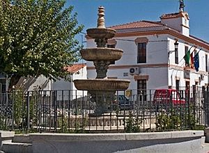
Abertura facts for kids
Quick facts for kids
Abertura
|
||
|---|---|---|

Plaza de España Abertura
|
||
|
||
| Country | Spain | |
| Autonomous community | Extremadura | |
| Province | Cáceres | |
| Area | ||
| • Total | 62.71 km2 (24.21 sq mi) | |
| Elevation | 314 m (1,030 ft) | |
| Population
(2018)
|
||
| • Total | 403 | |
| • Density | 6.426/km2 (16.644/sq mi) | |
| Time zone | UTC+1 (CET) | |
| • Summer (DST) | UTC+2 (CEST) | |
| Website | www.abertura.es | |
Abertura is a small town in Spain. It is located in the province of Cáceres. This area is part of the Extremadura region.
Abertura covers an area of about 62.71 square kilometers. In 2011, around 447 people lived there. By 2018, the population was about 403 people.
Contents
Exploring Abertura's Geography
This town is mostly flat. Its height above sea level is between 380 and 430 meters. The highest point is called Esparragosa.
Two important rivers flow through the area. These are the Búrdalo River and the Alcollarín River.
A Look at Abertura's Population Changes
The number of people living in Abertura has changed over time. Here's how the population has looked since 1900:

Here's a closer look at the population changes during the 2000s:
| 2001 | 2002 | 2003 | 2004 | 2005 | 2006 |
|---|---|---|---|---|---|
| 512 | 509 | 501 | 506 | 505 | 486 |
A Glimpse into Abertura's Past
In 1594, the area of Cáceres, which includes Abertura, was part of Trujillo. This was known as the Trujillo Province.
Later, around 1834, Abertura became a constitutional municipality. It was part of the Logrosán Judicial District. A census in 1842 showed that Abertura had 200 households. There were 1096 residents living there at that time.
Important Buildings in Abertura
Abertura has some interesting old buildings. These include:
- San Juan Bautista Parish Church (built in the 15th century)
- Santa Ana Hermitage
See also
 In Spanish: Abertura (Cáceres) para niños


