Salt gully wattle facts for kids
Quick facts for kids Salt gully wattle |
|
|---|---|
| Scientific classification | |
| Genus: |
Acacia
|
| Species: |
patagiata
|
 |
|
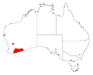
| Occurrence data from AVH | |
The Acacia patagiata, also known as the salt gully wattle, is a special kind of shrub. It belongs to the Acacia plant family. This plant is endemic to southwestern Australia. This means it naturally grows only in that specific area and nowhere else in the world!
What Does the Salt Gully Wattle Look Like?
This round shrub usually grows to be about 0.5 to 2.5 meters (1.6 to 8.2 feet) tall. Its small branches are smooth or have very few hairs. Like most Acacia plants, it doesn't have true leaves. Instead, it has phyllodes. These are flattened leaf stems that look and act like leaves.
The phyllodes of the salt gully wattle are stiff, leathery, and smooth. They are grey-green and have a pointed tip. They stand upright and can be slightly curved. Each phyllode is about 2.5 to 5.5 centimeters (1 to 2.2 inches) long and 3 to 8 millimeters (0.1 to 0.3 inches) wide. They have many fine lines, which are parallel veins, with one main vein standing out more than the others. This wattle blooms from July to September, showing off its bright yellow flowers.
How Was It Named?
Two botanists, Richard Sumner Cowan and Bruce Maslin, officially described this plant for the first time in 1990. They wrote about it in a scientific paper called Acacia Miscellany 3. This paper was published in a journal named Nuytsia.
The salt gully wattle looks a lot like another plant called Acacia lineolata subsp. multilineata. It also shares some similarities with Acacia unguicula and Acacia mimica.
Where Does It Grow?
This wattle is native to several regions in Western Australia. These areas include the Wheatbelt, Great Southern, and Goldfields-Esperance regions.
You can often find it growing along salty rivers and creeks. It also likes to grow near the edges of salt lakes and salt pans. It prefers sandy, sandy-loam, or clay soils. The plant's natural home stretches from around Pingrup in the northwest all the way to Mount Ney in the east.

