
Adams Branch (Richardson Creek tributary) facts for kids
Quick facts for kids Adams Branch |
|
|---|---|

Location of Adams Branch mouth
|
|
| Other name(s) | Tributary to Richardson Creek |
| Country | United States |
| State | North Carolina |
| Counties | Union |
| Physical characteristics | |
| Main source | divide between Adams Branch and Lynches River Pond about 1.5 miles southwest of Alton, North Carolina 698 ft (213 m) 34°53′01″N 080°35′26″W / 34.88361°N 80.59056°W |
| River mouth | Richardson Creek about 3 miles north-northwest of Alton, North Carolina 528 ft (161 m) 34°55′34″N 080°33′29″W / 34.92611°N 80.55806°W |
| Length | 4.64 mi (7.47 km) |
| Basin features | |
| Progression | generally north |
| River system | Pee Dee River |
| Basin size | 6.11 square miles (15.8 km2) |
| Tributaries |
|
| Bridges | Plyler Mill Road, Richardson Road, Austin Road, Buford Shortcut Road |
Adams Branch is a small stream, about 4.64 mi (7.47 km) long, located in Union County, North Carolina, United States. It is a tributary of Richardson Creek. The stream begins near a town called Alton and flows generally north until it joins Richardson Creek.
Contents
What is Adams Branch?
Adams Branch is a natural waterway, like a small river, that carries water across the land. It's part of a larger network of streams and rivers that eventually flow into the ocean.
Where Does Adams Branch Start?
The stream begins in Union County, North Carolina. Its starting point, or source, is a pond located about 1.5 miles southwest of a community called Alton. The land here is about 698 ft (213 m) above sea level.
Where Does Adams Branch End?
Adams Branch flows north and eventually empties into Richardson Creek. This meeting point is about 3 miles north-northwest of Alton. At this spot, the elevation is about 528 ft (161 m) above sea level.
How Does Adams Branch Connect to Other Rivers?
Adams Branch is part of a bigger river system. After joining Richardson Creek, its waters flow into the Pee Dee River. The Pee Dee River then travels through North Carolina and South Carolina before reaching the Atlantic Ocean. This means water from Adams Branch eventually makes its way to the sea!
The Area Around Adams Branch
The land area that collects water for Adams Branch is called its basin or watershed. This basin covers about 6.11 square miles (15.8 km2).
What Crosses Adams Branch?
Several roads have bridges that go over Adams Branch. These include Plyler Mill Road, Richardson Road, Austin Road, and Buford Shortcut Road. These bridges help people travel easily across the stream.
Images for kids
-
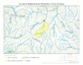
The path of Adams Branch
-
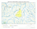
The area that drains into Adams Branch
.gif)
.gif)
