Airport, Roanoke, Virginia facts for kids
Quick facts for kids
Airport
|
|
|---|---|

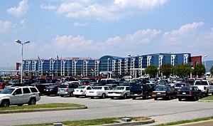
Roanoke Regional Airport terminal building
|
|
| Country | |
| State | |
| City | Roanoke |
| Time zone | UTC-5 (EST) |
| • Summer (DST) | UTC-4 (EDT) |
| ZIP Codes |
24012
|
| Area code(s) | 540 |
Airport is a Roanoke, Virginia neighborhood. It is located in the north-central part of Roanoke. This area is generally surrounded by Virginia State Route 118 to the south. Interstate 581 forms its western border. The neighborhood is centered around the Roanoke Regional Airport. It shares its western border with the Miller Court/Arrowood neighborhood. To the south, it borders Roundhill. The Airport neighborhood also touches Roanoke County on its north and east sides.
History of the Airport Neighborhood
How the Neighborhood Grew
The Airport neighborhood became part of Roanoke City in 1976. Before that, it was part of Roanoke County. Most of the buildings and businesses in this area are for commercial use. This means they are places like shops and offices, not homes.
Important Businesses and Places
One of the first big commercial developments was Crossroads Mall. It opened in 1961. This mall helped the area grow with more businesses. Today, the Airport neighborhood is still mainly a business area. It was also once home to the main office for Advance Auto Parts.
 | Claudette Colvin |
 | Myrlie Evers-Williams |
 | Alberta Odell Jones |


