Alberta, Virginia facts for kids
Quick facts for kids
Alberta, Virginia
|
|||
|---|---|---|---|
|
|||

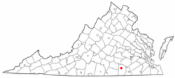
Location of Alberta, Virginia
|
|||
| Country | United States | ||
| State | Virginia | ||
| County | Brunswick | ||
| Area | |||
| • Total | 2.15 sq mi (5.56 km2) | ||
| • Land | 2.13 sq mi (5.53 km2) | ||
| • Water | 0.01 sq mi (0.03 km2) | ||
| Elevation | 397 ft (121 m) | ||
| Population
(2020)
|
|||
| • Total | 302 | ||
| • Density | 126.52/sq mi (48.85/km2) | ||
| Time zone | UTC-5 (Eastern (EST)) | ||
| • Summer (DST) | UTC-4 (EDT) | ||
| ZIP code |
23821
|
||
| Area code(s) | 434 | ||
| FIPS code | 51-00724 | ||
| GNIS feature ID | 1498398 | ||
Alberta is a small town located in Brunswick County, Virginia, in the United States. In 2020, about 302 people lived there. It is also home to the Christanna Campus of Southside Virginia Community College, a place where students can go to learn and get a college education.
Contents
History of Alberta
For many years in the 1900s, Alberta was an important spot where two main railroad lines met. These railroads were like busy highways for trains.
Early Railroads
One railroad, the Richmond, Petersburg and Carolina Railroad, was finished in 1900. It later became part of the Seaboard Air Line (SAL). By 1914, Alberta had about 100 people living there. This railway line was used until the 1980s. Today, parts of it are no longer used.
Another important railroad, the Virginian Railway, opened in 1907. It connected Norfolk to Victoria, Virginia. From 1909, this railway also carried coal from the Appalachian mountains. The Virginian Railway was used for many years. It was slowly closed down after joining with the Norfolk and Western railway.
Historic Places
Alberta is also home to two places that are listed on the National Register of Historic Places. These are special places that have been kept safe because of their history. They are called Hobson's Choice and Rocky Run Methodist Church.
Geography of Alberta
Alberta is found in the northern part of Brunswick County. It is located along a major road called U.S. Route 1.
Roads and Location
Interstate 85 also runs just south of the town. You can get to Alberta from Exit 28 on Interstate 85. The town's area stretches along Route 1 and I-85 to Virginia State Route 46. The Southside Virginia Community College is also in this area, and you can reach it from I-85 at Exit 27.
If you travel on I-85, it's about 40 miles (64 km) northeast to Petersburg. It's about 16 miles (26 km) southwest to South Hill.
Land and Water
The United States Census Bureau says that Alberta covers a total area of about 2.15 square miles (5.56 km2). Most of this area, about 2.14 square miles (5.53 km2), is land. A very small part, about 0.01 square miles (0.03 km2), is water.
Population of Alberta
The number of people living in Alberta has changed over the years. Here is a look at the population from different census counts:
| Historical population | |||
|---|---|---|---|
| Census | Pop. | %± | |
| 1930 | 328 | — | |
| 1940 | 416 | 26.8% | |
| 1950 | 430 | 3.4% | |
| 1960 | 430 | 0.0% | |
| 1970 | 466 | 8.4% | |
| 1980 | 394 | −15.5% | |
| 1990 | 337 | −14.5% | |
| 2000 | 306 | −9.2% | |
| 2010 | 298 | −2.6% | |
| 2020 | 302 | 1.3% | |
| U.S. Decennial Census | |||
In the year 2000, there were 306 people living in Alberta. These people lived in 128 households. A household is like a home where people live together. About 86 of these were families. The average number of people in each household was about 2.39.
Notable People
- Bill Connelly, a baseball player, is from Alberta.
See also
 In Spanish: Alberta (Virginia) para niños


