Aldermen Islands facts for kids

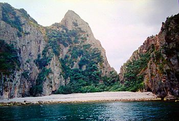
A bay on one of the Aldermen Islands.
|
|
| Geography | |
|---|---|
| Location | Mercury Bay in the North Island |
| Coordinates | 36°58′S 176°05′E / 36.967°S 176.083°E |
| Area | 1.3 km2 (0.50 sq mi) |
| Administration | |
| Demographics | |
| Population | 0 |
The Aldermen Islands are a small group of rocky islands. They are located in New Zealand, off the coast of the Coromandel Peninsula. These islands are a special nature reserve. They are home to rare animals and plants.
Contents
Discover the Aldermen Islands
The Aldermen Islands are found in the North Island of New Zealand. They are southeast of Mercury Bay. You can find them about 20 kilometers (12 miles) east of the mouth of the Tairua River. This makes them a unique spot in the ocean.
Who Named the Islands?
The islands were named by Captain Cook and his crew. This happened on November 3, 1769. They called them 'the Court of Aldermen'. This name was given after they had already named nearby Mayor Island.
What Makes These Islands Special?
The Aldermen group has four main islands. These are Hongiora, Middle, Ruamahuanui, and Ruamahuaiti. Together, they cover an area of about 133.5 hectares. That's like 330 football fields!
The islands are covered in forests. They are a protected nature reserve. This means they are a safe home for rare species. One very special animal found here is the tuatara. It's a reptile that looks like a lizard but is unique to New Zealand. Because they are so special, you need a special permit to visit these islands.
How Were the Islands Formed?
The Aldermen Islands are actually what's left of ancient volcanoes. They were formed from lava domes. These domes were created millions of years ago, during the Pliocene or Early Pleistocene periods. Over a very long time, wind and water eroded them. This erosion shaped them into the rocky islands we see today. They are part of a larger group of volcanic features called the Whitianga Group.
 | William Lucy |
 | Charles Hayes |
 | Cleveland Robinson |

