Altamira, Huila facts for kids
Quick facts for kids
Altamira, Huila
|
|||
|---|---|---|---|
|
Municipality and town
|
|||
|
|||

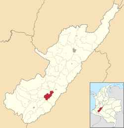
Location of the municipality and town of Altamira, Huila in the Córdoba Department of Colombia.
|
|||
| Country | |||
| Department | Huila Department | ||
| Founded | October 18, 1855 | ||
| Area | |||
| • Municipality and town | 188.18 km2 (72.66 sq mi) | ||
| Elevation | 1,080 m (3,540 ft) | ||
| Population
(2015)
|
|||
| • Municipality and town | 4,293 | ||
| • Density | 188.18/km2 (72.66/sq mi) | ||
| • Urban | 2,901 | ||
| Time zone | UTC-5 (Colombia Standard Time) | ||
Altamira is a small town and a special area called a municipality in the Huila Department of Colombia. It's a quiet place with a population of around 2,416 people.
Altamira is located in the beautiful Andes Mountains. It sits about 3,540 feet (1,079 meters) above sea level. This means it's quite high up! The town is about an 8-hour bus ride south of Bogota, the capital city of Colombia.
The biggest city in the Huila Department is Neiva. It's about 89 miles (143 kilometers) north of Altamira. Neiva has a much larger population, around 370,000 people. The road connecting these towns is paved and has two lanes.
You can see amazing mountains around Altamira. On a very clear day, you might even spot the Nevado del Huila volcano to the north. This volcano is super tall, reaching 17,601 feet (5,365 meters)! It's the highest volcano in Colombia and is always covered in snow and ice. Even though it's about 50 miles (80 kilometers) away, it stands out clearly on a sunny day.
Nearby Towns and Rivers
About a half-hour drive north of Altamira is Garzon. This is the closest city to Altamira. If you drive an hour south, you'll reach Pitalito, which is a larger city with about 69,000 people. The roads in this area are paved but can be very winding and steep because of the mountains.
Pitalito is also close to San Agustin. This place is famous for its ancient statues and artifacts made by people who lived there long, long ago. There's another similar archaeological site near a small town called Isnos.
The Rio Magdalena, a big river, flows through the valley north of Altamira. You can get to it from small towns like Tarqui or La Jagua.
Life in Altamira
In the center of Altamira, there's a main square called the centro parque. Here you'll find a school that teaches both primary and secondary students. The local church, called San Roque, is also in this square.
At the west end of town, there's a fun playground. It has courts for soccer and basketball, perfect for playing sports. There's also a swimming pool that's open every afternoon all year round, which is great for cooling off.
Local Products
The area around Altamira is great for growing many delicious tropical fruits. You'll find mangoes, papayas, oranges, bananas, and pineapples growing here.
Between Altamira and Garzon, there are many vineyards where grapes are grown. North of Garzon, farmers grow rice. One of the most important crops grown in the surrounding mountains is coffee.
In the mountains and valleys near Altamira, there are many small towns and tiny settlements called veredas. These can be reached by gravel roads. In the mountains above a town called Suaza, south of Altamira, there's a small church in the tiny town of Gallardo. Inside, you can see a statue of Our Lady of Aranzazu.
Climate
| Climate data for Altamira (1981–2010) | |||||||||||||
|---|---|---|---|---|---|---|---|---|---|---|---|---|---|
| Month | Jan | Feb | Mar | Apr | May | Jun | Jul | Aug | Sep | Oct | Nov | Dec | Year |
| Mean daily maximum °C (°F) | 27.7 (81.9) |
28.1 (82.6) |
27.8 (82.0) |
27.5 (81.5) |
27.4 (81.3) |
26.7 (80.1) |
26.0 (78.8) |
26.5 (79.7) |
27.7 (81.9) |
27.7 (81.9) |
27.1 (80.8) |
27.2 (81.0) |
27.3 (81.1) |
| Daily mean °C (°F) | 23.4 (74.1) |
23.4 (74.1) |
23.2 (73.8) |
23.2 (73.8) |
23.0 (73.4) |
22.5 (72.5) |
21.9 (71.4) |
22.4 (72.3) |
22.9 (73.2) |
22.9 (73.2) |
23.0 (73.4) |
23.1 (73.6) |
22.9 (73.2) |
| Mean daily minimum °C (°F) | 18.1 (64.6) |
18.2 (64.8) |
18.1 (64.6) |
18.2 (64.8) |
18.3 (64.9) |
17.9 (64.2) |
17.4 (63.3) |
17.4 (63.3) |
17.6 (63.7) |
17.8 (64.0) |
18.2 (64.8) |
18.2 (64.8) |
18.0 (64.4) |
| Average precipitation mm (inches) | 81.7 (3.22) |
104.8 (4.13) |
116.4 (4.58) |
112.6 (4.43) |
116.7 (4.59) |
79.0 (3.11) |
66.1 (2.60) |
40.2 (1.58) |
54.9 (2.16) |
106.6 (4.20) |
127.5 (5.02) |
86.5 (3.41) |
1,093.1 (43.04) |
| Average precipitation days | 12 | 14 | 17 | 18 | 20 | 17 | 18 | 16 | 15 | 18 | 18 | 15 | 195 |
| Average relative humidity (%) | 75 | 76 | 78 | 78 | 78 | 77 | 78 | 75 | 73 | 76 | 78 | 78 | 77 |
| Mean monthly sunshine hours | 170.5 | 132.7 | 120.9 | 120.0 | 145.7 | 135.0 | 124.0 | 124.0 | 135.0 | 148.8 | 147.0 | 173.6 | 1,677.2 |
| Mean daily sunshine hours | 5.5 | 4.7 | 3.9 | 4.0 | 4.7 | 4.5 | 4.0 | 4.0 | 4.5 | 4.8 | 4.9 | 5.6 | 4.6 |
| Source: Instituto de Hidrologia Meteorologia y Estudios Ambientales | |||||||||||||
See also
 In Spanish: Altamira (Huila) para niños
 | Chris Smalls |
 | Fred Hampton |
 | Ralph Abernathy |


