Altenburger Land Rural District facts for kids
Quick facts for kids
Altenburger Land
|
|
|---|---|
 |
|
| Country | |
| State | Thuringia |
| Capital | Altenburg |
| Area | |
| • Total | 569 km2 (220 sq mi) |
| Population
(2001)
|
|
| • Total | 113,500 |
| • Density | 199.47/km2 (516.6/sq mi) |
| Time zone | UTC+1 (CET) |
| • Summer (DST) | UTC+2 (CEST) |
| Vehicle registration | ABG |
| Website | altenburgerland.de |
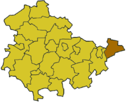
Altenburger Land is a rural district in Thuringia, Germany. Think of it like a county or a region in other countries. It's located in the eastern part of Thuringia and is mostly a farming area with lots of green fields.
A Look Back in Time
The city of Altenburg and the land around it have a long and interesting history. For many years, from 1826 to 1918, this area was a small independent state called the Duchy of Saxe-Altenburg. A duchy is a territory ruled by a duke or duchess.
After 1918, it became a state within the Weimar Republic, which was Germany's government after World War I. But this didn't last long. In 1922, the state of Saxe-Altenburg joined the larger state of Thuringia.
The district we know today as Altenburger Land has changed its shape a few times. It was first created in 1922 and was simply called "Altenburg." In 1952, it was split into two smaller districts: Altenburg and Schmölln. But in 1994, they were joined back together and given the name "Altenburger Land."
What the Coat of Arms Means
 |
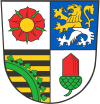
The coat of arms for Altenburger Land tells a story about its past. Each symbol has a special meaning:
|
Towns and Communities
Altenburger Land is home to several towns and many smaller communities. Here are some of the main towns in the district:
- Altenburg
- Gößnitz
- Lucka
- Meuselwitz
- Schmölln
There are also many other smaller towns and villages that make up the district, each with its own unique character.
See Also

