Alto Baudó facts for kids
Quick facts for kids
Alto Baudó
|
|
|---|---|
|
Municipality and town
|
|

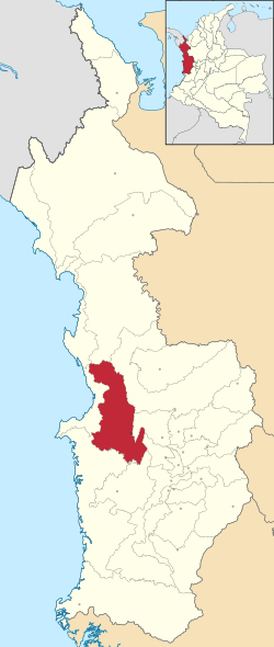
Location of the municipality and town of Alto Baudó in the Chocó Department of Colombia.
|
|
| Country | |
| Department | Chocó Department |
| Founded | November 25, 1958 |
| Area | |
| • Municipality and town | 1,532 km2 (591.5 sq mi) |
| Population
(2015)
|
|
| • Density | 24.00/km2 (62.17/sq mi) |
| • Urban | 9,563 |
| • Metro | 36,773 |
| Time zone | UTC-5 (Colombia Standard Time) |
Alto Baudó is a town and a "municipality" in Colombia. A municipality is like a local government area that includes a main town and the surrounding countryside. Alto Baudó is located in the Chocó Department, which is a region in western Colombia.
This area is home to a part of the Utría National Natural Park. This park is a special protected area where nature can thrive.
The Climate of Alto Baudó
Alto Baudó has a tropical rainforest climate. This means it is hot and rainy all year round, just like you would expect in a rainforest! The weather information below is for Pie de Pato, which is the main town in the municipality.
| Climate data for Pie de Pato | |||||||||||||
|---|---|---|---|---|---|---|---|---|---|---|---|---|---|
| Month | Jan | Feb | Mar | Apr | May | Jun | Jul | Aug | Sep | Oct | Nov | Dec | Year |
| Mean daily maximum °C (°F) | 29.5 (85.1) |
29.4 (84.9) |
29.8 (85.6) |
29.7 (85.5) |
29.7 (85.5) |
29.4 (84.9) |
29.5 (85.1) |
29.4 (84.9) |
29.3 (84.7) |
28.7 (83.7) |
28.9 (84.0) |
29.0 (84.2) |
29.4 (84.8) |
| Daily mean °C (°F) | 25.9 (78.6) |
25.8 (78.4) |
26.1 (79.0) |
26.1 (79.0) |
26.2 (79.2) |
25.9 (78.6) |
25.9 (78.6) |
25.9 (78.6) |
25.9 (78.6) |
25.4 (77.7) |
25.6 (78.1) |
25.6 (78.1) |
25.9 (78.5) |
| Mean daily minimum °C (°F) | 22.4 (72.3) |
22.2 (72.0) |
22.5 (72.5) |
22.6 (72.7) |
22.7 (72.9) |
22.4 (72.3) |
22.4 (72.3) |
22.4 (72.3) |
22.5 (72.5) |
22.2 (72.0) |
22.3 (72.1) |
22.3 (72.1) |
22.4 (72.3) |
| Average rainfall mm (inches) | 461.3 (18.16) |
407.3 (16.04) |
401.1 (15.79) |
557.7 (21.96) |
516.7 (20.34) |
567.4 (22.34) |
582.7 (22.94) |
643.7 (25.34) |
570.9 (22.48) |
567.8 (22.35) |
619.2 (24.38) |
494.5 (19.47) |
6,390.3 (251.59) |
| Average rainy days | 14 | 12 | 13 | 16 | 18 | 18 | 19 | 19 | 18 | 18 | 19 | 18 | 202 |
See also
 In Spanish: Alto Baudó para niños
Black History Month on Kiddle
African-American Labor Activists
 | Bayard Rustin |
 | Jeannette Carter |
 | Jeremiah A. Brown |

All content from Kiddle encyclopedia articles (including the article images and facts) can be freely used under Attribution-ShareAlike license, unless stated otherwise. Cite this article:
Alto Baudó Facts for Kids. Kiddle Encyclopedia.
