Amajari facts for kids
Quick facts for kids
Amajari
|
|||
|---|---|---|---|
|
Municipality
|
|||
| The Municipality of Amajari | |||

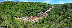
Paiva waterfall
|
|||
|
|||

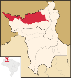
Location of Amajari in the State of Roraima
|
|||
| Country | |||
| Region | North | ||
| State | |||
| Founded | 17 October 1995 | ||
| Area | |||
| • Total | 28,472 km2 (10,993 sq mi) | ||
| Elevation | 100 m (300 ft) | ||
| Population
(2020)
|
|||
| • Total | 13,185 | ||
| • Density | 0.21/km2 (0.5/sq mi) | ||
| Time zone | UTC−4 (AMT) | ||
| HDI (2000) | 0.654 – medium | ||
| Website | amajari.rr.gov.br | ||
Amajari (Portuguese pronunciation: [ɐmaʒaˈɾi]) is a special type of town and region in Brazil. It is called a municipality. You can find Amajari in the northwest part of the state of Roraima.
About 13,185 people live in Amajari. It covers a very large area, about 28,472 square kilometers. This makes it the westernmost municipality in Roraima. Amajari was officially founded on October 17, 1995.
People and Culture
Amajari is home to many different groups of people. A big part of the population is made up of indigenous peoples. These are the first people who lived in this land.
Indigenous Communities
There are 8 main areas where indigenous people live in Amajari. These areas are called indigenous segments. Within these segments, there are 19 different communities. The main groups of people living here are the Macuxi, Wapichana, Sapará, and Taurepang people.
The 8 indigenous segments are:
- TI Araçá
- TI Ouro
- TI Anaro
- TI Ponta da Serra
- TI Aningal
- TI Garagem
- TI Santa Inês
- TI Ananás
The 19 indigenous communities include:
- Araçá
- Mutamba
- Mangueira
- Três Corações
- Guariba
- Anaro
- Ponta da Serra
- Urucuri
- Juraci
- Nova União
- Ouro
- San Francisco
- Cajueiro
- Garagem
- Ananás
- Leão de Ouro
- Santa Inês
- Aningal
- Vida Nova
Main Towns
Within the large municipality of Amajari, there are several smaller towns and villages. Here are some of the main populated places and how many people lived there in 2010:
- Vila Brasil: This is the largest town with 1,219 inhabitants.
- Vila Tepequém: This village had 116 inhabitants.
- Vila Três Corações: About 587 people lived here.
- Vila do Trairão: This town had 693 inhabitants.
Notable People
Some people from Amajari have become well-known.
- Suely Campos (born in 1953) is a famous politician from Amajari. A politician is someone who works in government. Suely Campos was once the governor of Roraima. A governor is like the leader of a state.
See also
 In Spanish: Amajari para niños
 | Shirley Ann Jackson |
 | Garett Morgan |
 | J. Ernest Wilkins Jr. |
 | Elijah McCoy |


