
Amhara Region facts for kids
Quick facts for kids
Amhara Region
አማራ
|
|||
|---|---|---|---|
|
Regional State
|
|||
 |
|||
|
|||

Map of Ethiopia showing Amhara Region
|
|||
| Country | Ethiopia | ||
| Capital | Bahir Dar | ||
| Area | |||
| • Total | 154,708.96 km2 (59,733.46 sq mi) | ||
| Area rank | 3 | ||
| Population
(2014)
|
|||
| • Total | 20,018,988 | ||
| • Rank | 2 | ||
| • Density | 129.397728/km2 (335.138578/sq mi) | ||
| ISO 3166 code | ET-AM | ||


The Amhara Region is a large area in Ethiopia. It is one of the ten regional states that make up the country. This region is the traditional home of the Amhara people. Its capital city is Bahir Dar.
About the Amhara Region
The Amhara Region is known for its amazing natural beauty. It has Lake Tana, which is the biggest inland lake in Ethiopia. This lake is also where the Blue Nile River starts its long journey.
The region is also home to the Semien Mountains National Park. This park is famous for its tall mountains and unique wildlife. Inside the park, you'll find Ras Dashan. This is the highest point in all of Ethiopia, reaching very high into the sky!
How Amhara is Organized
Like other regions in Ethiopia, Amhara is divided into smaller parts called administrative zones. These zones help manage the different areas within the region. Here are the main administrative zones:
- Agew Awi
- East Gojjam
- North Gondar
- North Shewa
- North Wollo
- Oromia
- South Gondar
- South Wollo
- Wag Hemra
- West Gojjam
- Bahir Dar (This is a special zone for the capital city)
Images for kids
-
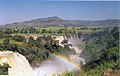
The Blue Nile Falls near Bahir Dar
-
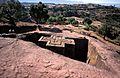
Bete Giyorgis, one of the churches in Lalibela.
-
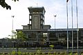
The Bahir Dar Airport in the Amhara region
-
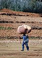
A farmer carrying hay from the fields to his home, Amhara


_AN0457026.jpg)
.jpg)
See also
 In Spanish: Región de Amhara para niños
