Bahir Dar facts for kids
Quick facts for kids
Bahir Dar
ባሕር ዳር (Amharic)
|
|
|---|---|
|
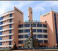
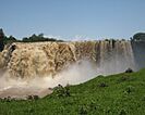
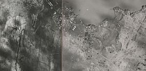
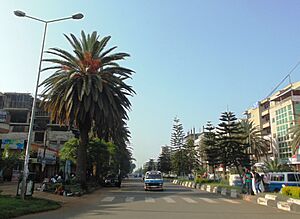
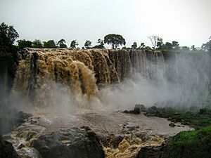
From top: The Blue Nile with the city of Bahir Dar; A street in Bahir Dar; A high-rise building; Bahir Dar University; Blue Nile Falls
|
|
| Country | |
| Region | |
| Zone | Bahir Dar Special Zone |
| Area | |
| • Total | 213.44 km2 (82.41 sq mi) |
| Elevation | 1,800 m (5,900 ft) |
| Population
(2024)
|
|
| • Total | 640,000 |
| • Estimate
(2023)
|
474,743 |
| • Density | 2,999/km2 (7,770/sq mi) |
| Time zone | UTC+3 (EAT) |
| Area code(s) | (+251) 58 |
Bahir Dar (which means "sea shore" in Amharic) is the capital city of the Amhara Region in Ethiopia. It is a popular place for tourists to visit in Ethiopia. Many people come to see the beautiful Lake Tana and the Blue Nile river nearby. The city is famous for its wide streets, which are lined with palm trees and many colorful flowers. In 2002, Bahir Dar won a special award called the UNESCO Cities for Peace Prize. This award recognized how well the city handled its fast growth.
Contents
History of Bahir Dar
How Bahir Dar Started
Long ago, this area was first known as Bahir Giyorgis. Between 1810 and 1900, about 1,200 to 2,000 people lived here. It grew from a monastery and became an important place for trading. In the 1800s, travelers from Europe visited Bahir Dar. They described it as either a small village or a town.
Bahir Dar in the 1900s
In the early 1900s, British teams came to Bahir Dar. They wanted to build a dam where the Blue Nile flows out of Lake Tana. In 1930, the Ethiopian government sent its own experts. They said Bahir Dar was a village with a lot of trade. People from inland areas and Lake Tana ports came here.
At that time, Bahir Dar had different areas where people lived. These areas were based on their social groups. The clergy (religious leaders) and local landowners were the most important groups. There were also groups of craftspeople like tanners, Muslim weavers, and stone-mill grinders. These groups depended on each other for trade. But they did not marry outside their own communities.
In May 1936, Italian forces took control of Bahir Dar. They added modern city features. They changed land ownership from shared family land to private land. They used some land for government buildings, the army, an airport, and port facilities. New areas for homes and shops were created. Bahir Dar became connected by boats on Lake Tana and by roads to other cities like Gonder and Addis Ababa.
The city's look and social life changed a lot. New communities formed, including an Italian camp, a Muslim area, and a Weyto quarter. Bahir Dar became a mix of different people and cultures. Shops, tea-rooms, and restaurants run by foreigners appeared for the first time. Ethiopians did not own many of these businesses.
The Italians made Bahir Dar an important administrative center for the southern Lake Tana areas. They were also interested in using Lake Tana and the Blue Nile for farming and hydroelectric power.
In 1941, the Ethiopian government took back control. They made Bahir Dar a capital city, first for a small area and then for a larger district. Many government offices and public services were set up. In 1945, Bahir Dar became a municipality, which means it had its own local government. In the early 1950s, it was even considered as a possible new capital city for Ethiopia.
During the 1960s and 1970s, Bahir Dar grew very quickly. It was the capital of the Gojjam province. The government helped it grow as a center for trade and transportation. German experts created a new plan for the city. This plan completely changed how Bahir Dar looked. It became a center for industry and economic growth. The city got a water supply, hydroelectric power, better lake port facilities, a bridge over the Abbay River, textile factories, a hospital, and higher education schools. These schools are now part of Bahir Dar University.
During the Ethiopian Civil War, there were some important events in Bahir Dar. In March 1990, some forces left the city and blew up a nearby bridge. This stopped other forces from taking over the city right away. However, the city was later reoccupied. On February 23, 1991, the Ethiopian People's Revolutionary Democratic Front (EPRDF) gained control of Bahir Dar.
In the 1990s, Bahir Dar continued to grow and expand. It became the capital of the Amhara National State. Ethiopia's new economic policies encouraged more businesses and investments. Today, Bahir Dar is a key center for government, business, industry, transport, communication, health, education, and tourism.
Bahir Dar in the 2000s
To celebrate the Millennium, Bahir Dar hosted a National Investment Bazaar and Trade Fair from January 6-9, 2007. More than 150 local and international companies took part in this event.
In June 2019, there were some serious events in the Amhara Region. Several government officials were assassinated in Bahir Dar and Addis Ababa. Among those who died were General Se'are Mekonnen and the President of Amhara Region, Ambachew Mekonnen. General Asaminew Tsige was also killed in Bahir Dar a few days later.
Geography and Climate
Bahir Dar is located where the Abbay River flows out of Lake Tana. It is about 1,820 meters (5,970 feet) above sea level. The city is about 578 kilometers (359 miles) north-northwest of Addis Ababa. The Lake Tana area has been a special UNESCO Biosphere Reserve since 2015. This means it's a protected area for nature and people.
Weather in Bahir Dar
Bahir Dar has a climate that is mostly tropical savanna. This means it has warm to hot afternoons all year round. Mornings are usually cool. The biggest difference between day and night temperatures happens during the dry season, when there are very few clouds.
| Climate data for Bahir Dar | |||||||||||||
|---|---|---|---|---|---|---|---|---|---|---|---|---|---|
| Month | Jan | Feb | Mar | Apr | May | Jun | Jul | Aug | Sep | Oct | Nov | Dec | Year |
| Record high °C (°F) | 37 (99) |
36 (97) |
36 (97) |
38 (100) |
38 (100) |
32 (90) |
30 (86) |
29 (84) |
29 (84) |
35 (95) |
35 (95) |
33 (91) |
38 (100) |
| Mean daily maximum °C (°F) | 26.7 (80.1) |
28.2 (82.8) |
29.5 (85.1) |
30.0 (86.0) |
29.2 (84.6) |
26.9 (80.4) |
24.4 (75.9) |
24.3 (75.7) |
25.5 (77.9) |
26.5 (79.7) |
26.7 (80.1) |
26.6 (79.9) |
27.0 (80.7) |
| Daily mean °C (°F) | 17.8 (64.0) |
19.4 (66.9) |
21.4 (70.5) |
22.4 (72.3) |
22.3 (72.1) |
20.9 (69.6) |
19.4 (66.9) |
19.2 (66.6) |
19.6 (67.3) |
19.9 (67.8) |
19.1 (66.4) |
18.0 (64.4) |
20.0 (67.9) |
| Mean daily minimum °C (°F) | 8.8 (47.8) |
10.5 (50.9) |
13.3 (55.9) |
14.7 (58.5) |
15.4 (59.7) |
14.9 (58.8) |
14.4 (57.9) |
14.1 (57.4) |
13.6 (56.5) |
13.3 (55.9) |
11.4 (52.5) |
9.4 (48.9) |
12.8 (55.1) |
| Record low °C (°F) | 8 (46) |
8 (46) |
9 (48) |
5 (41) |
6 (43) |
10 (50) |
9 (48) |
8 (46) |
7 (45) |
7 (45) |
9 (48) |
6 (43) |
5 (41) |
| Average precipitation mm (inches) | 2.3 (0.09) |
1.6 (0.06) |
6.7 (0.26) |
24.2 (0.95) |
90.9 (3.58) |
196.8 (7.75) |
410.0 (16.14) |
377.3 (14.85) |
199.9 (7.87) |
99.1 (3.90) |
15.3 (0.60) |
3.4 (0.13) |
1,427.5 (56.18) |
| Average rainy days (≥ 0.1 mm) | 1 | 1 | 2 | 3 | 10 | 18 | 28 | 28 | 20 | 10 | 3 | 1 | 125 |
| Source 1: Ethiopian Meteorological InstituteWorld Meteorological Organisation (rainy days) | |||||||||||||
| Source 2: National Meteorology Agency (records) | |||||||||||||
People of Bahir Dar
In 2007, a census showed that Bahir Dar Special Zone had 221,991 people. About 180,174 (81.16%) lived in the city, and the rest lived in nearby rural areas. Bahir Dar is one of Ethiopia's largest and fastest-growing cities. From 2007 to 2023, the city's population grew by about 5.31% each year.
| Historical population | ||
|---|---|---|
| Year | Pop. | ±% |
| 1984 | 54,800 | — |
| 1994 | 96,140 | +75.4% |
| 2007 | 155,428 | +61.7% |
| 2023 | 365,957 | +135.5% |
| source: | ||
Ethnic Groups and Languages
In 2007, the main ethnic groups in Bahir Dar Special Zone were the Amhara (96.23%), Tigrayan (1.11%), and Oromo (1.10%). Other groups made up a small part of the population. Most people (96.77%) spoke Amharic as their first language. A smaller number spoke Oromiffa (1.03%) or Tigrinya (0.98%).
Ethnic groups of Bahir Dar as of 2007[update] Amhara (96.23%) Tigrayan (1.11%) Agew (1.10%) Other (1.56%)
Religions in Bahir Dar

According to the 2007 census, most people (89.72%) in Bahir Dar practiced Ethiopian Orthodox Christianity. About 8.47% were Muslim, and 1.62% were Protestants.
The Ethiopian Catholics also have a cathedral in the city. This cathedral is the main church for the Ethiopic Catholic Diocese of Bahir Dar–Dessie.
Culture and Attractions
Bahir Dar has a small daily market and a much larger weekly market. There are also some music clubs in the city.
The Blue Nile Falls (called Tis Issat) are about 30 kilometers (19 miles) south of the city. A hydroelectric power dam has been built, which means less water now flows over the falls. However, the Blue Nile Falls are still a major tourist attraction, especially during the rainy season when the water level is higher and the falls are more impressive.
Education in Bahir Dar
Bahir Dar is home to several universities and colleges. The most well-known is Bahir Dar University. In October 2012, it expected to have over 40,000 students. Today, Bahir Dar University has more than 40,000 students. Emperor Haile Selassie opened the Technical School at Bahir Dar University on June 11, 1963.
Ethiopia's university system has been growing very fast in the 21st century. Bahir Dar University is one of the largest universities in Ethiopia. It has 45,000 students in 65 undergraduate and 67 graduate programs. The university was created in 2000 by combining the Bahir Dar Polytechnic and Bahir Dar Teachers' College.
The university helps Ethiopia reach its goal of becoming a "middle-income country" by 2025. It has eleven research centers that focus on important studies. The university also supports primary and secondary education by training teachers. This helps improve reading and writing skills and creates more job and higher education chances for people. Degrees in science and health also help address the shortage of healthcare workers in Ethiopia.
Other schools in Bahir Dar include Alkan University College and the Institute of Land Administration, which started in 2006. The city also has many government schools, including a STEM-focused High School located within the university. There are also private schools like Bahir Dar Academy, Rispins International School, and an SOS school.
Getting Around Bahir Dar
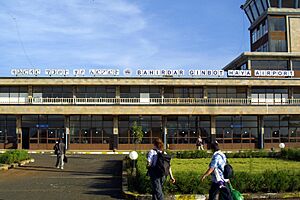
For air travel, Bahir Dar is served by the Bahir Dar Dejazmach Belay Zeleke Airport. There are up to ten flights each day to and from Addis Ababa. The airport's runway was made longer to handle international flights. This means products like flowers can now be exported by air.
The city is also connected by roads and bus lines to other cities. The easiest and most common way to travel within Bahir Dar is by cycling. Auto rickshaws and share taxis are also available for transportation in the city. For travel between cities, bus companies like Selam Bus Line Share Company, Abay Bus s.c, Ethio Bus s.c, and Sky Bus Transport System offer daily services to and from the capital. Their ticket offices are mainly in the mall at the south end of the main street.
As of 2021, a new road bridge across the Nile River was being built. This bridge will soon carry the main road to the northern parts of the city and on to Gondar.
Sports in Bahir Dar
Association football (soccer) is the most popular sport in Bahir Dar. The city has two main sports venues: the 60,000-seat Bahir Dar Stadium and the 15,000-seat Bahir Dar University Stadium.
Sister Cities
Bahir Dar is connected with other cities around the world as "sister cities." These partnerships help promote cultural exchange and friendship. Bahir Dar is twinned with:
 Ashdod, Israel (since 2011)
 Cleveland, United States (since 2004)
 Madison, United States (since 2018)
 Oakland, United States (since 2010)
See also
 In Spanish: Bahir Dar para niños
- Ethiopian Airlines Flight 604 – an aircraft accident at the airport in 1988
 | Roy Wilkins |
 | John Lewis |
 | Linda Carol Brown |


