Amokura railway station facts for kids
Quick facts for kids
Amokura railway station
|
|||||||||||
|---|---|---|---|---|---|---|---|---|---|---|---|

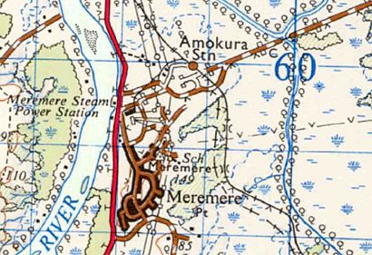
1961 Amokura railway station
on Sheet N52 one inch map |
|||||||||||
| Location | New Zealand | ||||||||||
| Coordinates | 37°18′32″S 175°04′34″E / 37.309°S 175.076°E | ||||||||||
| Elevation | 7 m (23 ft) | ||||||||||
| Line(s) | North Island Main Trunk | ||||||||||
| Distance | Wellington 604.43 km (375.58 mi) | ||||||||||
| Tracks | double to north single to south |
||||||||||
| History | |||||||||||
| Opened | 1929 | ||||||||||
| Closed | 1980 | ||||||||||
| Services | |||||||||||
|
|||||||||||
Amokura railway station was a train station located in the Waikato region of New Zealand. It was an important stop on the North Island Main Trunk railway line. This long railway line connects many towns and cities across the North Island.
The station was about 604 kilometers (375 miles) away from Wellington, the capital city. Amokura station was at the northern end of a 13-kilometer (8-mile) section of railway line that only had one track. This meant trains had to take turns using that part of the line.
When Amokura Station Was Open
There are different ideas about when Amokura station first opened. Some records say it opened for goods trains on October 20, 1929. Passenger trains started using it a little later, on November 11, 1929.
However, other information suggests the station might have opened much earlier, on August 13, 1877. It's possible that the earlier date refers to the railway line itself, or perhaps a different kind of stop.
Changes Over Time
In January 1929, a special railway track called a "siding" was officially named Amokura. A siding is a short track next to the main line where trains can wait or load/unload goods. An article from 1930 made it seem like this siding was quite new.
Around 1929, the station was also sometimes known by other names, like Ngatikoi or Raumoa.
A "crossing loop" at the station was closed on May 13, 1963. A crossing loop is a section of track that allows trains going in opposite directions to pass each other on a single-track line.
At that time, there was a plan to combine Amokura station with a nearby station called Meremere. The two stations were very close, only about 22 meters (24 yards) apart. Meremere was a bigger and more well-known station.
Amokura railway station eventually closed down in 1980.
External links
 | James B. Knighten |
 | Azellia White |
 | Willa Brown |


