An-Nabek District facts for kids
Quick facts for kids
an-Nabek District
منطقة النبك
|
|
|---|---|
|
District
|
|

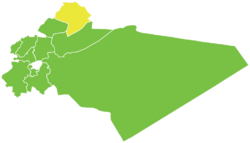
Map of an-Nabek District within Rif Dimashq Governorate
|
|
| Country | |
| Governorate | Rif Dimashq |
| Seat | an-Nabek |
| Subdistricts | 3 nawāḥī |
| Area | |
| • Total | 1,122.87 km2 (433.54 sq mi) |
| Population | |
| • Total | 80,001 |
| • Density | 71.2469/km2 (184.5286/sq mi) |
| Geocode | SY0306 |
The an-Nabek District is a special area in southern Syria. It is part of the Rif Dimashq Governorate. The main city and administrative center of this district is an-Nabek.
In 2004, about 80,001 people lived in the an-Nabek District. This area is also known by another name, Qalamoun. You might see it spelled as Qalamun or Kalamoun too.
Parts of the District
The an-Nabek District is divided into three smaller parts. These parts are called nawāḥī (sub-districts). Each sub-district has its own main town or city.
The three sub-districts are:
- an-Nabek Subdistrict
- Deir Atiyah Subdistrict
- Qara Subdistrict
Towns and Villages
Many towns and villages are located within the an-Nabek District. The Central Bureau of Statistics keeps track of them. Here are some of the main places:
- an-Nabek: This is the largest city in the district.
- Qara: A significant town in its own sub-district.
- Deir Atiyah: Another important town, also a sub-district center.
- Flitah (Meshrefah)
- al-Sahel
- al-Jarajir
- al-Qastal
- Qaldoun al-Marah
- al-Humayra
See also
 In Spanish: Distrito de An-Nabek para niños
Black History Month on Kiddle
Famous African-American Scientists:
 | Charles R. Drew |
 | Benjamin Banneker |
 | Jane C. Wright |
 | Roger Arliner Young |

All content from Kiddle encyclopedia articles (including the article images and facts) can be freely used under Attribution-ShareAlike license, unless stated otherwise. Cite this article:
An-Nabek District Facts for Kids. Kiddle Encyclopedia.
