Anegam, Arizona facts for kids
Quick facts for kids
Anegam, Arizona
|
|
|---|---|
|
Populated place
|
|

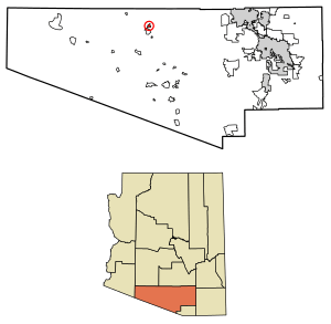
Location of Anegam in Pima County, Arizona.
|
|
| Country | United States |
| State | Arizona |
| County | Pima |
| Area | |
| • Total | 2.31 sq mi (5.99 km2) |
| • Land | 2.31 sq mi (5.99 km2) |
| • Water | 0.00 sq mi (0.00 km2) |
| Elevation | 1,762 ft (537 m) |
| Population
(2010)
|
|
| • Total | 151 |
| • Estimate
(2016)
|
N/A |
| Time zone | UTC-7 (Mountain (MST)) |
| • Summer (DST) | UTC-7 (MST) |
| ZIP code |
85634
|
| Area code(s) | 520 |
| FIPS code | 025-02270 |
| GNIS feature ID | 652 |
Anegam is a small community located in Pima County, Arizona, United States. Its name comes from the O'odham language and means "Desert Willow." It is a "populated place" and also a census-designated place (CDP). This means it's an area identified by the U.S. Census Bureau for statistical purposes.
Anegam is found within the Tohono O'odham Indian Reservation. This reservation is the homeland of the Tohono O'odham people. In 2010, about 151 people lived in Anegam. By 2015, the number grew slightly to 154. The community sits about 1,762 feet (537 meters) above sea level.
How Many People Live There?
| Historical population | |||
|---|---|---|---|
| Census | Pop. | %± | |
| 1960 | 35 | — | |
| 2010 | 151 | — | |
| U.S. Decennial Census | |||
The number of people living in Anegam has changed over time. In 1960, only 35 people were counted in the census.
When the 2010 U.S. Census happened, Anegam was officially recognized as a census-designated place (CDP). At that time, 151 residents were recorded. The 2020 census showed the population was 149 people.
Learning in Anegam
Students in Anegam attend schools within the Indian Oasis-Baboquivari Unified School District. This school district serves the local communities, including those on the Tohono O'odham Nation.
See also
 In Spanish: Anegam (Arizona) para niños


