
Angerville, Calvados facts for kids
Quick facts for kids
Angerville
|
|
|---|---|
 |
|

Angerville
Location in France

Angerville
Location in Normandy
|
|
| Country | France |
| Region | Normandy |
| Department | Calvados |
| Arrondissement | Lisieux |
| Canton | Cabourg |
| Intercommunality | Normandie-Cabourg-Pays d'Auge |
| Area
1
|
3.91 km2 (1.51 sq mi) |
| Population
(2014)
|
132 |
| • Density | 33.76/km2 (87.4/sq mi) |
| Time zone | UTC+01:00 (CET) |
| • Summer (DST) | UTC+02:00 (CEST) |
| INSEE/Postal code |
14012 /14430
|
| Elevation | 14–120 m (46–394 ft) (avg. 50 m or 160 ft) |
| 1 French Land Register data, which excludes lakes, ponds, glaciers > 1 km2 (0.386 sq mi or 247 acres) and river estuaries. | |
Angerville, Calvados is a small commune in the northwest of France. It is located in the region called Basse-Normandie. This area is also part of the Calvados department.
About Angerville
Angerville is a quiet place in the French countryside. A "commune" is like a small town or village with its own local government. It's the smallest type of administrative area in France.
Where is Angerville?
Angerville is found in the Normandy region of France. This region is famous for its history and beautiful landscapes. The commune is part of the Calvados department. This department is known for its apple orchards and dairy farms.
Life in Angerville
Angerville is a very small commune. In 2014, only about 132 people lived there. The area of Angerville is about 3.91 square kilometers. This is roughly the size of 391 football fields.
The land in Angerville is not flat. Its elevation, or height above sea level, ranges from 14 meters to 120 meters. The average elevation is about 50 meters.
The local leader of Angerville is called the mayor. The mayor helps run the commune and make decisions for the people. From 2014 to 2020, the mayor was Thierry de Vanssay. Angerville also works with nearby communes in a group called "Normandie-Cabourg-Pays d'Auge." This group helps them share services and work together.
Images for kids
-
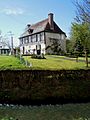
The Town hall next to the Ancre river.
-
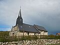
The church of Angerville.

See also
 In Spanish: Angerville (Calvados) para niños
