Anna Site facts for kids

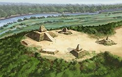
Artists conception of the Anna Site
|
|
| Location | Natchez, Mississippi, Adams County, Mississippi, |
|---|---|
| Region | Adams County, Mississippi |
| Coordinates | 31°41′43.37″N 91°20′59.17″W / 31.6953806°N 91.3497694°W |
| History | |
| Founded | 1200 |
| Abandoned | 1500 |
| Periods | Anna Phase |
| Cultures | Plaquemine culture |
| Site notes | |
| Excavation dates | 1924, 1997 |
| Archaeologists | Warren K. Moorehead, James A. Ford, Jesse D. Jennings, John L. Cotter |
| Architecture | |
| Architectural styles | platform mound |
| Architectural details | Number of temples: 8 |
|
Anna Site
|
|
| NRHP reference No. | 93001606 |
| Significant dates | |
| Added to NRHP | September 14, 1993 |
| Designated NHL | September 14, 1993 |
| Responsible body: Private | |
The Anna Site (also known as 22 AD 500) is an ancient place where people lived a long time ago. It's an archaeological site from the Plaquemine culture. You can find it in Adams County, Mississippi, about 10 kilometers (6 miles) north of Natchez, Mississippi. This site is very important. It helps us understand the "Anna Phase" of the Plaquemine culture, which lasted from about 1200 to 1350 CE. Because it's so important, it was named a National Historic Landmark in 1993.
Contents
Exploring the Anna Site
The Anna Site sits high up on a bluff. This bluff is right above the Mississippi River. It's about 10 kilometers (6 miles) north of Natchez, Mississippi.
What are Mounds?
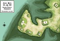
The site has eight large platform mounds. These are human-made hills. People built them for special buildings or ceremonies. Six of these mounds are placed around a central open area called a plaza.
Layout of the Mounds
The main group of six mounds is close to the bluff. Mound 3 is the biggest. It's about 15 meters (50 feet) tall. It sits right on the edge of the bluff, looking over the river. A ramp goes down from Mound 3 to the plaza. This ramp leads towards Mound 5. Mound 5 is smaller, about 3.6 meters (12 feet) tall, and about 91 meters (300 feet) away.
Mound 4 is a small mound next to Mound 3. It's just off the plaza. Digs here found signs of a building on top. Mound 1 is another small mound. It's on the southern side of Mound 3. Mound 2 is between Mound 1 and Mound 5, along the plaza. Mounds 3, 2, and 5 are lined up with the plaza. Mound 6 is placed diagonally. It also has parts of a ramp.
Two other mounds, Mound 7 and Mound 8, are located east and northeast of the main group. Deep ditches, called ravines, surround the mounds. Pieces of Plaquemine culture pottery are found all over the area.
History of the Anna Site
Building at the Anna Site started around 1200 CE. This was when different groups of people in the Lower and Middle Mississippi River area began to interact. Their interactions led to the start of the Plaquemine culture.
Early Days and Growth
Some people lived at the site before 1200 CE. But the most important time for the site began during the Gordon Phase (1000–1200 CE). This was part of the Coles Creek culture period. Mound building might have started then. It definitely began by the next period, the Anna Phase (1200 to 1350 CE). Building continued through the Foster Phase (1350-1500 CE) and the Emerald Phase (1500 to 1680 CE).
Over these 300 years, the Anna Site grew. It became a very important center in the region. It might have been ruled by powerful leaders whose positions were passed down through their families. People lived at the site until about 1500 CE. After that, it seems no one lived there again.
Archaeological Discoveries
Archaeologists have studied the Anna Site for many years.
- In 1924, Warren K. Moorehead and Calvin S. Brown dug at the site.
- Later, James A. Ford, Jesse D. Jennings, and John L. Cotter also worked there.
Ford and Jennings suggested that the State of Mississippi buy the site. They wanted it for future digs and maybe a museum. But this never happened.
John L. Cotter's work in 1951 was very important. His digs and studies helped create the timeline for the Natchez Bluffs area. In 1997, more digs were done. These were by the Gulf Coast Survey and the Alabama Museum of Natural History. Their work confirmed the timeline that Cotter had set up.
 | Selma Burke |
 | Pauline Powell Burns |
 | Frederick J. Brown |
 | Robert Blackburn |


