
Plaquemine culture facts for kids
The Plaquemine culture was a group of Native American people who lived in the Lower Mississippi River valley from about 1200 CE to 1700 CE. They were ancestors of the historic Natchez and Taensa peoples. This culture had deep roots in the area, growing from earlier groups like the Coles Creek and Troyville cultures. The Medora site in Louisiana is a very important place for understanding the Plaquemine culture, as it's where archaeologists first defined it. Other key sites include Anna, Emerald, Holly Bluff, and Winterville in Mississippi.
| Alternative names | Plaquemine Mississippian |
|---|---|
| Geographical range | Lower Mississippi Valley Gulf Coast |
| Period | Mississippian |
| Dates | c. 1200 CE — c. 1700 CE |
| Type site | Medora site |
| Major sites | Anna, Atchafalaya Basin, Emerald, Grand Village, Holly Bluff, Mazique, Sims, Winterville |
| Preceded by | Coles Creek culture |
| Followed by | Mississippian, Protohistoric Natchez and Taensa peoples, |

Contents
History of the Plaquemine People
What Was the Plaquemine Culture?
The Plaquemine culture was a unique part of the larger Mississippian culture. They lived along the Mississippi River valley, from the Gulf of Mexico up to where it meets the Arkansas River. This area included parts of Mississippi, Arkansas, and Louisiana. These people were mostly farmers. They grew important crops like corn, pumpkins, squash, beans, and tobacco. They also hunted, fished, and gathered wild plants for food.
The Medora site in Louisiana is known as the "type site" for the Plaquemine culture. This means it's the main place where archaeologists first studied and defined what made this culture special. The site was used from about 1300 to 1600 CE. It had two large platform mounds with a flat area, called a plaza, between them. Pottery found at Medora was mostly made with crushed rock or clay mixed in (called "grog-tempered"). Only a little bit of pottery had crushed shell mixed in. These pottery styles, along with growing lots of corn, became key signs of the Plaquemine culture.
How the Plaquemine Culture Grew
The Plaquemine culture developed from an earlier group called the Coles Creek culture (700 to 1200 CE). The Plaquemine people had a lot of contact with Mississippian cultures living to their north and east. For example, the powerful city of Cahokia (near modern-day St. Louis, Missouri) was at its peak during the early Plaquemine period.
After Cahokia declined in the mid-1300s, the Plaquemine people lived alongside other Mississippian groups. Archaeologists still discuss whether the Plaquemine culture developed mostly on its own or if changes happened because of contact with their Mississippian neighbors. Many Coles Creek sites continued to be used by their Plaquemine descendants, and some Plaquemine sites were still active in the early 1700s when Europeans first arrived.
Plaquemine settlements were often ceremonial centers. Only important leaders, priests, and their helpers lived there all the time. Most people lived in smaller villages and farms spread out across the land. During this time, the population grew a lot, and more and larger sites appeared. Big sites like Winterville or Emerald might have been centers of powerful chiefdoms. These chiefdoms were led by a main chief who had control over other smaller centers. Power could sometimes shift between these centers, leading to some sites being partly or completely left empty.


Plaquemine and Mississippian Influences
Around 1150 to 1250 CE, Mississippian cultures from further north began to spread their influence south. In the Yazoo Basin area of Mississippi, archaeologists found items from Cahokia, like special pottery. This shows that Plaquemine people had contact with Cahokia. Through these interactions, groups in Mississippi and Louisiana started using Mississippian ways of making pottery and ceremonial objects. They might have also adopted some Mississippian social structures.
By the mid-1400s, influences from the Pensacola culture (from places like the Bottle Creek Indian Mounds near Mobile, Alabama) also spread westward. By 1700, these influences had changed the local populations as far north as modern-day Baton Rouge, Louisiana. For example, pottery at sites like the Sims site in Louisiana started using crushed shell instead of grog for tempering.
Over time, the Plaquemine people adopted more Mississippian influences. The area where their unique culture was strongest began to shrink after 1350 CE. Eventually, the last place where a purely Plaquemine culture existed was the southern Natchez Bluffs area. Other areas, like the Yazoo Basin and parts of Louisiana, became a mix of Plaquemine and Mississippian cultures.

First European Encounters
The first European record of the Plaquemine culture might be from the Spanish explorer Hernando de Soto in 1542. De Soto's expedition met a powerful chiefdom called "Quigualtam" on the east bank of the Mississippi River. The native people already knew about the Spanish expedition's harsh treatment of other groups. Their meeting with Quigualtam was short and violent, with the natives attacking the Spaniards in canoes.
After de Soto's expedition, no Europeans contacted these groups for almost 140 years. During this time, the native people suffered greatly from diseases brought by Europeans. These diseases spread even if people didn't directly meet the Europeans. The arrival of Europeans also upset the balance between native groups, who had often been at war with each other. Many societies in the region began to fall apart.
Some Mississippian groups started moving across and down the Mississippi River. Mississippian influences spread south into traditional Plaquemine territory. For example, the Jordan Mounds site in Louisiana was built by Mississippianized people who might have been refugees escaping the chaos caused by European contact. Other groups, like the Tunica, almost disappeared, with only small groups moving to former Plaquemine lands. The Central Mississippi Valley, once heavily populated, became almost empty.

The Plaquemine in Later Times
Even as Mississippian influences surrounded them, some Plaquemine groups continued into the historic era in the Natchez Bluffs area. This is seen in their social organization, language, and pottery styles. Perhaps because their encounter with de Soto was so brief, the Plaquemine Natchez and Taensa peoples were unique. They kept their complex chiefdoms, with hereditary leaders, mound ceremonies, and even human sacrifice, long after Europeans began to settle in America. They were the last groups to truly represent the Plaquemine culture. Other groups in the area had either moved there or had become more like the Mississippian cultures.
Plaquemine Culture and Daily Life
Homes and Villages
The Plaquemine people had complex political and religious systems. They lived in villages centered around large ceremonial places. These centers usually had two or more platform mounds facing an open plaza. Mounds were often built in special places, like old burial grounds or temple sites. These flat-topped, pyramid-shaped mounds were built in several stages, growing larger over time. New buildings were usually constructed on top of them after each expansion.
In earlier times, buildings were often round. Later, they became more rectangular. They were built using a method called "wattle and daub," where woven branches (wattle) were covered with mud or clay (daub). Sometimes, shallow graves were dug in the mounds for burials. These might have been for new burials or for reburying remains from special mortuary houses.
The layout of their villages, with plazas flanked by mounds, was passed down from their ancestors. This arrangement was common throughout the southeastern United States. The open plaza areas were used for public ceremonies and events. These included important rituals like the Green Corn Ceremony and games such as chunkey and the ballgame.
-
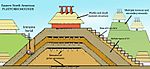
A diagram showing the different parts of platform mounds.
-
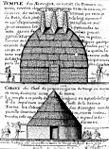
A drawing by an eyewitness, Alexandre de Batz, showing the Great Temple and the Great Sun's cabin.
-
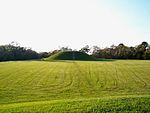
A smaller mound on top of the huge Emerald Mound.
-
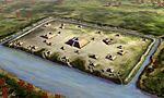
The arrangement of mounds and plaza at the Holly Bluff site.
-
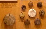
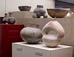
Stone discoidals used for the game of chunkey, found at Winterville.


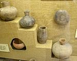
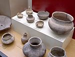
Plaquemine Pottery
Plaquemine pottery had its own special designs. Potters sometimes added small, solid handles called "lugs." They also textured the surface by brushing grass over the clay before firing it. They would cut designs into the wet clay. Like their Caddoan neighbors, the Plaquemine people also engraved designs on pots after they were fired. They also made plain pots for everyday use.
Pottery was often placed in burials as grave goods. Sometimes, these pots were "killed" by making a hole in their base while they were being made.
-
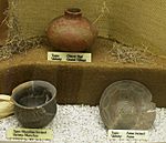
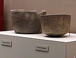
Natchez pottery from the Grand Village site.
-
Natchez pottery from the Grand Village site.
-
Natchez pottery from the Grand Village site.
-
Natchez pottery from the Grand Village site.


Plaquemine pottery continued to use "grog tempering," just like their Coles Creek ancestors. Using crushed mussel shell tempering was a clear sign of contact with Mississippian cultures. Pottery from early Natchez sites in western Mississippi still used traditional Plaquemine grog tempering and pot shapes. However, the pottery of the Taensa people in eastern Louisiana used Mississippian-style shell tempering and shapes, but still had Plaquemine decorative designs. This shows how Mississippian influences spread into the area over time.
-
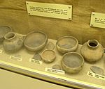
Pottery from the Winterville site.
-
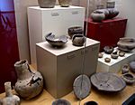
Pottery from the Winterville site.
-
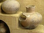
Pottery from the Winterville site.
-
Pottery from the Winterville site.


Important Plaquemine Sites
| Site Name | Image | What Makes It Special |
|---|---|---|
| Anna site |  |
Located in Adams County, Mississippi, about 10 miles (16 km) north of Natchez. It's a key site for understanding the early Plaquemine period in the Natchez Bluff region. |
| Atchafalaya Basin Mounds | Also known by other names, this site was used by Coastal Coles Creek and later Plaquemine people. It was also used by the Chitimacha Tribe in the 1700s. It has several platform mounds and a shell midden around a central plaza. | |
| Emerald Mound site |  |
Located about 8 miles (13 km) north of Natchez. It's the second largest ancient structure in the USA. It's important for understanding the later Plaquemine period in the Natchez Bluffs. |
| Fitzhugh Mounds |  |
A Plaquemine and Mississippian site in Madison Parish, Louisiana, used from about 1200 to 1541 CE. |
| Flowery Mound | A single mound site in Tensas Parish, Louisiana, dating from about 1200 to 1541 CE. | |
| Foster's Mound | A site with two mounds in Adams County, Mississippi, used from about 1350 to 1500 CE. | |
| Ghost Site Mounds | A site in Tensas Parish, Louisiana with parts from both the Coles Creek (700–1200 CE) and Plaquemine (1200 to 1541 CE) periods. | |
| Glass site | A large site in Warren County, Mississippi with four mounds around an open plaza. Three mounds still exist today. | |
| Grand Village of the Natchez or Fatherland Site |  |
A historic Plaquemine site located in Natchez, Mississippi. It's one of the few mound sites still in use when Europeans arrived. |
| Holly Bluff site |  |
A Plaquemine and Mississippian site in central western Mississippi, also known as the Lake George Site. |
| Jaketown Site |  |
A site with two mounds in Humphreys County, Mississippi. It was used from 1750 BCE to 1500 CE, making it one of the oldest continuously inhabited sites in the region. |
| Julice Mound | A mound site in East Carroll Parish, Louisiana, dating from 1200 to 1541 CE. | |
| Mangum Mound Site |  |
A Plaquemine site in Claiborne County, Mississippi. Special copper plates with bird designs were found here in 1936. |
| Mazique Archeological Site |  |
A multi-mound site in Adams County, Mississippi. It was used during both the Coles Creek and Plaquemine periods. In historic times, it was known as the White Apple village of the Natchez people. |
| Medora site |  |
A Plaquemine site in West Baton Rouge Parish, Louisiana. This is the most important site for defining the Plaquemine culture. |
| Pocahontas Mounds |  |
A multi-mound site in Hinds County, Mississippi, dating from 1000 to 1300 CE. It has a platform mound, a burial mound, and a village area. |
| Routh Mounds | A multi-mound site in Tensas Parish, Louisiana, important for understanding the early Plaquemine period in the Tensas Basin. | |
| Scott Place Mounds | A multi-mound site from the Late Coles Creek-Early Plaquemine period in Union Parish, Louisiana. | |
| Sims site | A multi-mound site in St. Charles Parish, Louisiana, first used by Coles Creek people around 800 CE. It transitioned to Plaquemine culture by 1100 CE and was used until about 1700 or 1800 CE. | |
| Transylvania Mounds | A large multi-mound site with two plazas in East Carroll Parish, Louisiana. It was used during the Coles Creek and Plaquemine periods. | |
| Venable Mound | A single mound site in Morehouse Parish, Louisiana, with parts from the Troyville, Coles Creek, and Plaquemine periods. | |
| Winterville site |  |
A Plaquemine and Mississippian site near Greenville, Mississippi. It's a key site for understanding the Plaquemine period in the Yazoo Basin. |
