Anse la Raye District facts for kids
Quick facts for kids
Anse la Raye District
|
|
|---|---|
|
District
|
|

Anse la Raye Bay
|
|

Anse la Raye District
|
|
| Country | Saint Lucia |
| Area | |
| • Total | 37.6 km2 (14.5 sq mi) |
| • Land | 31 km2 (12 sq mi) |
| Population
(2010)
|
|
| • Total | 6,060 |
| • Density | 161.2/km2 (417.4/sq mi) |
| ISO 3166-2:LC |
LC-01
|
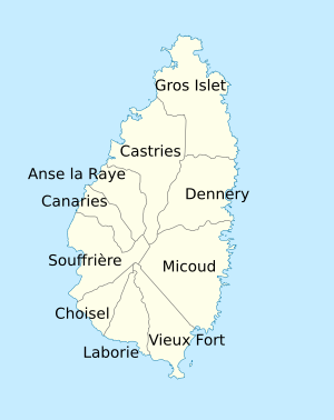
Anse la Raye District is one of the 10 main areas, or districts, on the beautiful island nation of St. Lucia. This island is located in the sunny Caribbean Sea. The name "Anse la Raye" comes from French. It means "bay of the rays," because many skate fish, also called rays, live in the bay.
In 2010, about 6,060 people lived in the district. Most of them work as fishers or in farming. The main town in this area is also called Anse La Raye. It is found on the western coast, south of Castries, which is the capital city of Saint Lucia.
History
Long ago, when France ruled Saint Lucia, Anse la Raye was a place with many sugar farms. These farms were called plantations. A special sign in a park in Anse la Raye town, put up in 2010, tells us this. Church records from 1775 show there were as many as 107 farms in the area.
During the French Revolution, people who were forced to work on these farms were set free. The town's name was even changed to L'Egalite, meaning "Equality." After they were freed, many farms were burned. Most people left the land and started fishing to make a living.
Later, in the mid-1900s, growing bananas and making coconut oil became important. Building boats also became a big part of life there. Anse la Raye is famous for its fast feather racing boats and exciting canoe races. In the late 1990s, a "Friday Fish Night" started in Anse la Raye town. It became a very popular event for locals and visitors.
Big hurricanes hit Saint Lucia in 1780 and 1817. These storms caused a lot of damage. Many ships that were docked in Anse la Raye were destroyed.
Geography
Anse la Raye District has several rivers flowing through it. Here are some of them:
- Grande Rivière de l'Anse la Raye, where it meets the sea: 13°56′21″N 61°02′39″W / 13.93915°N 61.04426°W
- Petite Riviere de l'Anse La Raye, where it meets the sea: 13°56′31″N 61°02′37″W / 13.942032°N 61.043529°W
- Roseau River, where it meets the sea: 13°57′36″N 61°01′57″W / 13.959965°N 61.032363°W
- Millet River: 13°55′29″N 60°59′22″W / 13.924778°N 60.989491°W
- Bois d’Inde Ravine: 13°56′45″N 61°01′01″W / 13.945857°N 61.016987°W
- Anse Galet River: 13°56′05″N 61°03′00″W / 13.934742°N 61.049942°W
- Ravine Saut: 13°55′11″N 61°01′11″W / 13.919848°N 61.019801°W
- Ravine Bordeneve: 13°55′11″N 61°01′12″W / 13.919788°N 61.019952°W
- Durandeau Ravine: 13°55′35″N 60°59′33″W / 13.926309°N 60.992434°W
There are also several beautiful bays (called "Anse" in French) in the area:
- Anse Pilori: 13°57′01″N 61°02′24″W / 13.950167°N 61.040045°W
- Anse Galet: 13°56′10″N 61°03′04″W / 13.936217°N 61.051057°W
- L'Anse La Raye: 13°56′26″N 61°02′45″W / 13.940686°N 61.045772°W
- Roseau Bay: 13°57′36″N 61°02′05″W / 13.960072°N 61.03466°W
You can also find the Anse la Raye waterfalls here. They are about 15 m (49 ft) (about 49 feet) tall. You can find them at: 13°55′39″N 61°01′31″W / 13.927464659613808°N 61.025338246103026°W.
Points
There are two points, or pieces of land sticking out into the Caribbean Sea, in Anse la Raye District:
- Pilori Point: 13°57′23″N 61°02′17″W / 13.956252°N 61.038178°W
- Pointe d'Orange: 13°56′33″N 61°02′43″W / 13.942471°N 61.045338°W
Mountains
Anse la Raye District is home to two mountains:
- Grande Rivière: 13°56′00″N 61°02′00″W / 13.933333°N 61.033333°W
- Derrière Dos: 13°55′06″N 61°00′10″W / 13.918308°N 61.002859°W
Populated places
The Anse la Raye District is divided into 27 smaller areas. These areas are used when counting the population for official records.
Here are some of the main towns and villages in Anse la Raye District:
- Anse La Raye: 13°56′24″N 61°02′33″W / 13.939881°N 61.042507°W
- Au Tabor: 13°56′39″N 61°02′31″W / 13.944181°N 61.042056°W
- Dame de Traversay: 13°55′15″N 60°59′16″W / 13.920961°N 60.987722°W
- Derrière Lagoon: 13°56′34″N 61°00′57″W / 13.942863°N 61.015727°W
- Durandeau: 13°55′35″N 60°59′37″W / 13.926301°N 60.993513°W
- Massacré: 13°57′00″N 61°02′13″W / 13.950075°N 61.036924°W
- Millet: 13°54′11″N 60°59′42″W / 13.902941°N 60.9949°W
- Roseau Valley: 13°57′11″N 61°01′36″W / 13.95317°N 61.02676°W
There are also two specific locations, or "localities," in the district:
- Fond Eau Rouge: 13°56′45″N 61°01′46″W / 13.945797°N 61.029399°W
- Anse Galet: 13°55′43″N 61°02′21″W / 13.928576°N 61.039189°W
Government
The main office for the Anse la Raye District's government is in the town of Anse la Raye.
The people of Anse la Raye District have a voice in their country's government. They are represented in the House of Assembly of Saint Lucia. Their current representative is the Honorable Wayne D. Girard. He is the person chosen by the voters to speak for the Anse La Raye/Canaries area.
See also
 In Spanish: Distrito de Anse La Raye para niños
- Geography of Saint Lucia
- List of cities in Saint Lucia
- List of rivers of Saint Lucia
- Districts of Saint Lucia
 | Precious Adams |
 | Lauren Anderson |
 | Janet Collins |

