Apple Valley, Utah facts for kids
Quick facts for kids
Apple Valley
|
|
|---|---|

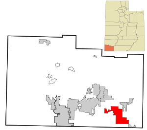
Location in Washington County and the state of Utah
|
|
| Country | United States |
| State | Utah |
| County | Washington |
| Incorporated | October 15, 2004 |
| Area | |
| • Total | 39.74 sq mi (102.93 km2) |
| • Land | 39.74 sq mi (102.93 km2) |
| • Water | 0.00 sq mi (0.00 km2) |
| Elevation | 4,961 ft (1,512 m) |
| Population
(2020)
|
|
| • Total | 855 |
| • Estimate
(2019)
|
844 |
| • Density | 21.24/sq mi (8.20/km2) |
| Time zone | UTC-7 (Mountain (MST)) |
| • Summer (DST) | UTC-6 (MDT) |
| ZIP code |
84737
|
| Area code(s) | 435 |
| GNIS feature ID | 2412373 |
Apple Valley is a small town located in Washington County, Utah, United States. It is about 12 miles east of Hurricane. The town sits along SR-59. In 2020, the census showed that 855 people lived there.
Contents
Becoming a Town
Apple Valley officially became an incorporated town on October 15, 2004. This means it gained the power to govern itself. When a place incorporates, it can make its own local rules. It can also provide services like police or fire departments.
Early Population Growth
After becoming a town, its population started to grow. In 2007, the US Census Bureau estimated about 427 people lived in Apple Valley. By 2019, the population estimate grew to 844 residents.
Votes on Staying a Town
Sometimes, people in a new town might change their minds. In 2006, some residents wanted to disincorporate Apple Valley. This means they wanted it to stop being an official town. They felt it became a town too soon. They gathered enough signatures to hold a vote. However, the attempt to disincorporate was not successful. Another vote happened on June 19, 2012. This vote also failed, meaning Apple Valley remained a town.
Who Lives in Apple Valley?
This section talks about the people who live in Apple Valley. It uses information from the census. A census counts how many people live in an area. It also gathers other facts about them.
Population Numbers
| Historical population | |||
|---|---|---|---|
| Census | Pop. | %± | |
| 2010 | 701 | — | |
| 2019 (est.) | 844 | 20.4% | |
| U.S. Decennial Census | |||
According to the 2010 census, 701 people lived in Apple Valley. There were 295 homes or housing units in the town.
Background of Residents
The census also looks at the background of the people. In 2010, most residents were White, making up 94.3% of the population. About 3.0% were American Indian and Alaska Native. A small number, 0.1%, were Asian. Another 1.3% were from other races. Finally, 1.3% were from two or more races. About 3.3% of the total population were of Hispanic or Latino background.
See also
 In Spanish: Apple Valley (Utah) para niños
 | Toni Morrison |
 | Barack Obama |
 | Martin Luther King Jr. |
 | Ralph Bunche |


