
Arkansas–White–Red water resource region facts for kids
The Arkansas–White–Red water resource region is one of 21 main areas that experts use to divide up the United States based on where water flows. Think of it like a giant map where each section shows where all the rain and snow eventually drain into a big river or a group of rivers. This helps scientists at the United States Geological Survey study water and how it moves across the land.
This special region has a code, HUC 11, which helps identify it. It's super big, covering about 247,988 square miles (642,290 square kilometers). That's a lot of land! This huge area is made up of 14 smaller sections, each with its own special code from 1101 to 1114.
The Arkansas–White–Red region includes all the land that drains into the Arkansas, White, and Red Rivers. These rivers eventually flow towards the Mississippi River. This region covers all of Oklahoma and parts of Arkansas, Colorado, Kansas, Louisiana, Missouri, New Mexico, and Texas.

Exploring the Water Subregions
This large water region is divided into 14 smaller parts, called subregions. Each subregion focuses on a specific part of the river system. They help scientists understand how water moves through different areas.
Here are some of the subregions:
- Upper White subregion (HUC 1101): This area covers the upper part of the White River Basin, including the Little Red River. It's found in Arkansas and Missouri.
- Upper Arkansas subregion (HUC 1102): This is the top part of the Arkansas River Basin. It stretches across Colorado, Kansas, and New Mexico.
- Middle Arkansas subregion (HUC 1103): This section of the Arkansas River Basin is found in Colorado and Kansas.
- Upper Cimarron subregion (HUC 1104): This area includes the beginning of the Cimarron River Basin. It's in Colorado, Kansas, New Mexico, and Oklahoma.
- Lower Cimarron subregion (HUC 1105): This part of the Cimarron River Basin is closer to where it joins the Arkansas River. It's in Kansas and Oklahoma.
- Arkansas–Keystone subregion (HUC 1106): This section of the Arkansas River Basin is located in Kansas and Oklahoma.
- Neosho–Verdigris subregion (HUC 1107): This area includes the Neosho and Verdigris River Basins. It spans Arkansas, Kansas, Missouri, and Oklahoma.
- Upper Canadian subregion (HUC 1108): This covers the upper part of the Canadian River Basin. You can find it in Colorado and New Mexico.
- Lower Canadian subregion (HUC 1109): This part of the Canadian River Basin is further downstream. It's in New Mexico, Oklahoma, and Texas.
- North Canadian subregion (HUC 1110): This area covers the North Canadian River Basin. It's found in Kansas, New Mexico, Oklahoma, and Texas.
- Lower Arkansas subregion (HUC 1111): This section of the Arkansas River Basin is closer to the Mississippi River. It's in Arkansas and Oklahoma.
- Red headwaters subregion (HUC 1112): This includes the starting points of several branches of the Red River. It's in New Mexico, Oklahoma, and Texas.
- Red–Washita subregion (HUC 1113): This part of the Red River Basin is above Denison Dam. It's located in Oklahoma and Texas.
- Red–Sulphur subregion (HUC 1114): This is the lowest part of the Red River Basin. It's found in Arkansas, Louisiana, Oklahoma, and Texas.
Images for kids
-
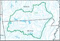
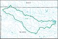
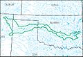
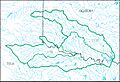
Map of the Upper White subregion (HUC 1101)
-
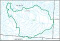
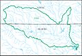
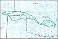
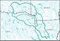
Map of the Upper Arkansas subregion (HUC 1102)
-
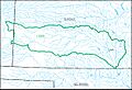
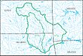
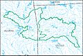
Map of the Middle Arkansas subregion (HUC 1103)
-
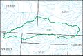
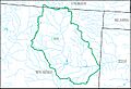
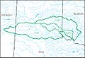
Map of the Upper Cimarron subregion (HUC 1104)
-
Map of the Lower Cimarron subregion (HUC 1105)
-
Map of the Arkansas–Keystone subregion (HUC 1106)
-
Map of the Neosho–Verdigris subregion (HUC 1107)
-
Map of the Upper Canadian subregion (HUC 1108)
-
Map of the Lower Canadian subregion (HUC 1109)
-
Map of the North Canadian subregion (HUC 1110)
-
Map of the Lower Arkansas subregion (HUC 1111)
-
Map of the Red headwaters subregion (HUC 1112)
-
Map of the Red–Washita subregion (HUC 1113)
-
Map of the Red–Sulphur subregion (HUC 1114)


