Arlington Heights, Ohio facts for kids
Quick facts for kids
Arlington Heights, Ohio
|
|||
|---|---|---|---|
|
Village
|
|||

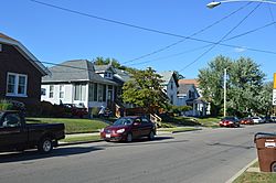
Houses on Elliott Avenue
|
|||
|
|||

Location in Hamilton County and the state of Ohio.
|
|||
| Country | United States | ||
| State | Ohio | ||
| County | Hamilton | ||
| Area | |||
| • Total | 0.26 sq mi (0.68 km2) | ||
| • Land | 0.26 sq mi (0.68 km2) | ||
| • Water | 0.00 sq mi (0.00 km2) | ||
| Elevation | 554 ft (169 m) | ||
| Population
(2020)
|
|||
| • Total | 823 | ||
| • Estimate
(2023)
|
810 | ||
| • Density | 3,141.22/sq mi (1,212.81/km2) | ||
| Time zone | UTC-5 (Eastern (EST)) | ||
| • Summer (DST) | UTC-4 (EDT) | ||
| ZIP code |
45215
|
||
| Area code(s) | 513 | ||
| FIPS code | 39-02428 | ||
| GNIS feature ID | 1086198 | ||
Arlington Heights is a small village in Hamilton County, Ohio, in the United States. It is a suburb located northeast of Cincinnati. In 2020, the village had a population of 823 people. A unique feature of Arlington Heights is that it is mostly found within the wide middle section of the Mill Creek Expressway (Interstate 75). This is one of the few places in the country where a highway splits around an urban area.
Contents
Where is Arlington Heights?
Arlington Heights is located in Hamilton County, Ohio. According to the United States Census Bureau, the village covers a total area of about 0.27 square miles (0.68 square kilometers). All of this area is land.
Who Lives in Arlington Heights?
Let's look at how the number of people living in Arlington Heights has changed over the years:
- 1890: 222 people
- 1900: 360 people
- 1910: 468 people
- 1920: 730 people
- 1930: 1,214 people
- 1940: 1,222 people
- 1950: 1,312 people
- 1960: 1,355 people
- 1970: 1,403 people
- 1980: 1,082 people
- 1990: 1,084 people
- 2000: 899 people
- 2010: 745 people
- 2020: 823 people
Population in 2020
In 2020, there were 823 people living in Arlington Heights. This means there were about 3,142 people per square mile. There were 402 homes in the village.
Most of the people in the village were White (65.4%). About 26.2% were Black or African American. A small number of people were from other racial backgrounds. About 2.9% of the population were Hispanic or Latino.
The average age of people in the village was 34.9 years. About 26.6% of the population were under 18 years old. About 16.1% were 65 years or older.
Population in 2010
In 2010, there were 745 people living in the village. The population density was about 2,759 people per square mile. There were 382 homes.
The racial makeup of the village in 2010 was mostly White (80.7%). About 14.8% were African American. A small percentage were from other racial groups. About 0.9% of the population were Hispanic or Latino.
The median age in the village in 2010 was 36.3 years. About 23.1% of residents were under 18 years old. About 10.9% were 65 years or older.
See also
 In Spanish: Arlington Heights (Ohio) para niños
 | May Edward Chinn |
 | Rebecca Cole |
 | Alexa Canady |
 | Dorothy Lavinia Brown |


