
Arroyo Naranjo facts for kids
Quick facts for kids
|
|
|---|---|
 |
|

Location of Arroyo Naranjo in Havana
|
|
| Country | Cuba |
| Province | Ciudad de La Habana |
| Wards (Consejos Populares) | Callejas, Calvario-Fraternidad, Eléctrico, Guinera, Los Pinos, Managua, Mantilla, Párraga, Poey, Víbora Park |
| Area | |
| • Total | 83 km2 (32 sq mi) |
| Elevation | 85 m (279 ft) |
| Population
(2022)
|
|
| • Total | 206,918 |
| • Density | 2,493/km2 (6,460/sq mi) |
| Time zone | UTC-5 (EST) |
| Area code(s) | +53-7 |
Arroyo Naranjo is one of the 15 main areas, called municipalities, in the city of Havana, Cuba. It became part of Havana as the city grew bigger over time.
You can find the Managua Military Airport in the southern part of this municipality.
History of Arroyo Naranjo
This area was first settled in 1845. By 1848, it had its own local government. Arroyo Naranjo is about 11 kilometers (7 miles) south of Old Havana. It was an important stop for buses traveling between Havana and Las Vegas.
In 1858, Arroyo Naranjo had 291 people living there. This number grew during certain times of the year. People came because of the nearby special waters known as Cacahual, which were thought to have healing powers. Arroyo Naranjo always had a growing population. By 1871, the town had 1,485 residents.
In 1939, a famous painter named Carlos Enriquez bought a small house here. He called it "El Huron Azul," which means "The Blue Ferret." This house became a popular meeting spot for Cuba's new and exciting artists. Today, it is a museum that shows Enriquez's artwork.
Population and Area
In 2022, the municipality of Arroyo Naranjo had a population of 206,918 people. The total area of Arroyo Naranjo is about 83 square kilometers (32 square miles). This means there are about 2,500 people living in each square kilometer.
Images for kids
-
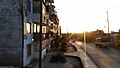
A view of Arroyo Naranjo.
-
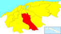
A map showing where Arroyo Naranjo is located in Havana.
See also
 In Spanish: Arroyo Naranjo para niños
