
Arta Region facts for kids
Quick facts for kids
Arta Region
Gobolka Carta إقليم عرتا |
|
|---|---|
 |
|
| Country | |
| Administrative centre | Arta |
| Area | |
| • Total | 1,800 km2 (700 sq mi) |
| Population
(2019)
|
|
| • Total | 50,017 |
| • Density | 27.8/km2 (72.0/sq mi) |
| Time zone | UTC+3 (EAT) |
| ISO 3166 code | DJ-AR |
Arta Region is one of the six main areas in the country of Djibouti. It is located in the eastern part of Djibouti. The capital city of this region is Arta.
Other towns in the region include We`a, Damerjog, and Loyada. The Hemed mountain is the highest point in the Arta Region. To the east, the Arta Region shares a border with the country of Somalia.
Contents
What is Arta Region?
The Arta Region is one of the six parts that make up the country of Djibouti. These parts are called "regions" or "Gobolka" in the local language. Each region helps to organize the country.
Where is Arta Region located?
Arta Region is found in the eastern part of Djibouti. It has a coastline along the Gulf of Tadjoura. This gulf is part of the Indian Ocean. The region also shares a border with the country of Somalia to its east.
The Capital City: Arta
The main city in the Arta Region is called Arta. This city is the Administrative centre. This means that important government offices for the region are located here. It is where decisions for the region are often made.
Towns and Mountains
Besides Arta, there are other towns in the region. These include We`a, Damerjog, and Loyada. The region is also home to the Hemed mountain. This mountain is the highest point in the Arta Region.
How many people live there?
As of 2019, about 50,017 people live in the Arta Region. The region covers an area of about 1,800 square kilometers (about 695 square miles).
Images for kids
-
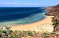
A beach on the Gulf of Tadjoura.
-
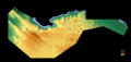
A topographic map of the Region of Arta.
-
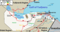
Map of the Arta Region.


See also
 In Spanish: Región de Arta para niños
