Ashburnham County facts for kids
Quick facts for kids AshburnhamNew South Wales |
|||||||||||||||
|---|---|---|---|---|---|---|---|---|---|---|---|---|---|---|---|

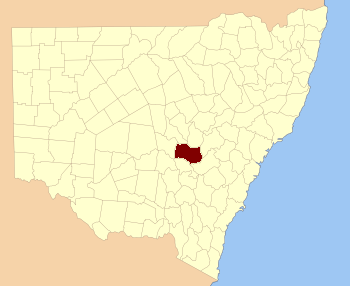
Location in New South Wales
|
|||||||||||||||
|
|||||||||||||||
Ashburnham County, New South Wales is one of the many special areas that help divide up the land in New South Wales, Australia. It's like a really old way of mapping out different parts of the state. You can find important towns like Parkes and Forbes inside its borders. The beautiful Lachlan River and Belubula River form its southern edge.
What is Ashburnham County?
This county is one of 141 "cadastral divisions" in New South Wales. Think of a cadastral division as an old-fashioned way of drawing lines on a map to keep track of land. These divisions were used for things like property records and planning.
Ashburnham County is located in the central-west part of New South Wales. It's known for its rich farming land and the important towns within its boundaries.
Who was Ashburnham County named after?
Ashburnham County was named to honor a person named Bertram Ashburnham. He lived from 1797 to 1878. In 1830, he became the 4th earl of Ashburnham. An earl is a noble title, similar to a duke or a count, used in the United Kingdom. Naming places after important people was a common practice in the past.

