Ashfield Plain Historic District facts for kids
Quick facts for kids |
|
|
Ashfield Plain Historic District
|
|

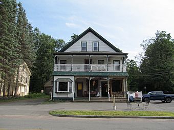
Elmers Store on Main Street
|
|
| Location | Roughly along Main and South Sts. and adjacent parts of Buckland and Norton Hill Rds., Ashfield, Massachusetts |
|---|---|
| Area | 133 acres (54 ha) |
| Built | 1812 |
| Architect | Lilly, Jonathan; Et al. |
| Architectural style | Greek Revival, Late Victorian, Federal |
| NRHP reference No. | 91001373 |
| Added to NRHP | September 20, 1991 |
The Ashfield Plain Historic District is a special area in Ashfield, Massachusetts. It includes parts of Main Street, South Street, and nearby roads. This district is like the heart of the town. It has been an important place for shops and town activities since the late 1700s. Many of its buildings are from the late 1800s and early 1900s. This historic area was added to the National Register of Historic Places in 1991.
Contents
Discovering Ashfield's History
Ashfield was first settled in 1736. It officially became a town in 1765. The very first town center was a bit northeast of where it is today. Later in the 1700s, the center moved. It moved to an area called "The Plain."
Why "The Plain" Became Important
"The Plain" was a great spot for a town center. It was a flat area in a mostly hilly region. It was also along the main road. This road led east toward the Connecticut River valley. Because of its location, it was a natural place for businesses to open. Taverns and other shops started to gather there.
Farming and Early Industries
Ashfield's economy was mostly about farming. But small factories also grew along the South River. This river runs north of Main Street. In the early 1800s, a dam was built. This dam created Ashfield Great Pond. The pond helped power the small factories.
Exploring the Historic District
The historic district mainly stretches along Main Street. This road is also known as Massachusetts Route 116. It goes from Ashfield Great Pond in the west to Bishop Corner Road in the east. The district also goes north along Bishop Corner Road. It covers about 133 acres (54 hectares).
Buildings in the District
Most of the buildings are one or two stories tall. They are made of wood. The center of the village has many shops. These are also made of wood. Most of the town's public buildings are here too.
Ashfield Town Hall's Journey
One important building is Ashfield's Town Hall. It was built in the 1810s. It was first used as a church, the First Congregational Church. While still a church, the building was moved. It traveled about half a mile down a steep hill. It was moved to its current spot. In 1870, the town bought the building. They changed it to become the Town Hall.


