Ashley Reservoir facts for kids
Quick facts for kids Ashley Reservoir |
|
|---|---|

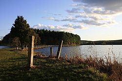
Shores of the Ashley Reservoir at dusk
|
|
| Official name | Ashley Reservoir |
| Country | United States of America |
| Location | Holyoke, Massachusetts |
| Purpose | Drinking water supply |
| Status | Operational |
| Opening date | 1873 |
| Owner(s) | City of Holyoke |
| Operator(s) | Holyoke Water Works |
| Reservoir | |
| Creates | Ashley Pond, Wright Pond |
| Total capacity | 795 million gallons |
| Catchment area | 1,261 acres |
| Surface area | 211 acres |
| Maximum length | 640 feet |
| Maximum water depth | 12 feet |
| Website http://www.holyoke.org/departments/water-works/ |
|
The Ashley Reservoir is a very important place in Holyoke, Massachusetts. It is the second main source of drinking water for the city. This reservoir is made up of two smaller ponds, called Wright Pond and Ashley Pond.
Together, these ponds can hold over 795 million gallons of water! They can also provide 2.1 million gallons of water every single day. That's a lot of water for people to drink and use.
The Ashley Reservoir was finished and started working in 1897. It is connected to another smaller reservoir, called McLean Reservoir. A special pumping plant, run by the Holyoke Water Works, moves water between them. There is a gravel road around the reservoir that people can use for fun activities.
Animals and Nature
The Ashley Reservoir is a home for many different animals. You might see bears, deer, geese, ducks, and beavers living here. It's a great place for wildlife!
Visiting the Reservoir
The main goal of the Ashley Reservoir is to provide clean drinking water. Because of this, there are special rules to protect the water. Most areas around the reservoir are only open for walking. You can park your car in a few special spots.
It is very important to keep the water clean. For this reason, fishing is not allowed in the reservoir. This helps stop unwanted plants or animals from getting into the water.
Many other activities are also not allowed. These include bringing dogs, riding horses, camping, smoking, sledding, and riding motorcycles. These rules help keep the drinking water safe and clean for everyone in Holyoke. You can enjoy walking on the paths and roads around the reservoir. Just remember that it is a source of drinking water, so some activities are limited.
See Also
- Tighe-Carmody Reservoir
- Whiting Street Reservoir
 | Frances Mary Albrier |
 | Whitney Young |
 | Muhammad Ali |

