Aspermont, Texas facts for kids
Quick facts for kids
Aspermont, Texas
|
|
|---|---|

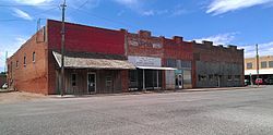
A row of buildings south of the Stonewall County Courthouse in Aspermont, Texas
|
|
| Country | United States |
| State | Texas |
| County | Stonewall |
| Area | |
| • Total | 2.07 sq mi (5.37 km2) |
| • Land | 2.05 sq mi (5.32 km2) |
| • Water | 0.02 sq mi (0.05 km2) |
| Elevation | 1,775 ft (541 m) |
| Population
(2020)
|
|
| • Total | 789 |
| • Density | 384.13/sq mi (148.31/km2) |
| Time zone | UTC−6 (Central (CST)) |
| • Summer (DST) | UTC−5 (CDT) |
| ZIP code |
79502
|
| Area code(s) | 940 |
| FIPS code | 48-04408 |
| GNIS feature ID | 2411650 |
Aspermont is a small town in Texas, United States. It is the main town, or county seat, of Stonewall County. In 2020, about 789 people lived there.
Contents
History of Aspermont
The town of Aspermont was first started in 1889. It has grown and changed over the years.
Geography and Climate in Aspermont
Aspermont covers about 2.1 square miles (5.4 square kilometers) of land. It does not have any large bodies of water.
Weather in Aspermont
Aspermont has a humid subtropical climate. This means it has hot, humid summers and mild winters. The weather here is often sunny.
The hottest temperature ever recorded in Aspermont was 117°F (47°C) on June 28, 1994. The coldest temperature recorded was -10°F (-23°C) on December 23, 1989.
Population of Aspermont
Aspermont has seen its population change over time. Here is how the number of people living in Aspermont has changed:
| Historical population | |||
|---|---|---|---|
| Census | Pop. | %± | |
| 1890 | 205 | — | |
| 1920 | 436 | — | |
| 1930 | 769 | 76.4% | |
| 1940 | 1,041 | 35.4% | |
| 1950 | 1,062 | 2.0% | |
| 1960 | 1,286 | 21.1% | |
| 1970 | 1,198 | −6.8% | |
| 1980 | 1,357 | 13.3% | |
| 1990 | 1,214 | −10.5% | |
| 2000 | 1,021 | −15.9% | |
| 2010 | 919 | −10.0% | |
| 2020 | 789 | −14.1% | |
| U.S. Decennial Census | |||
Who Lives in Aspermont?
In 2020, there were 789 people living in Aspermont. These people lived in 372 households. About 277 of these households were families.
Most people in Aspermont are White (69.2%). About 25.22% of the people are Hispanic or Latino. Other groups include Black or African American, Native American, Asian, and people of mixed races.
Education in Aspermont
Students in Aspermont go to schools in the Aspermont Independent School District. The town is home to the Aspermont High School Hornets.
Getting Around Aspermont
Roads and Highways
Several important roads pass through Aspermont. These roads help people travel to and from the town.
 U.S. Route 83
 U.S. Route 380
 Farm to Market 610
 Farm to Market 1263
 Farm to Market 2211
 Farm to Market 3457
Airport
Aspermont also has its own airport called Stonewall County Airport. It is a public airport located just northeast of the town center. The airport is mainly used for general aviation, which means it's for private planes and small aircraft, not big passenger jets.
See also
 In Spanish: Aspermont para niños
 | Kyle Baker |
 | Joseph Yoakum |
 | Laura Wheeler Waring |
 | Henry Ossawa Tanner |

