Attenhofen facts for kids
Quick facts for kids
Attenhofen
|
||
|---|---|---|

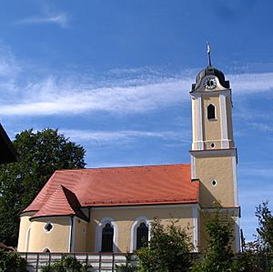
Church of Saint Nicholas
|
||
|
||
| Country | Germany | |
| State | Bavaria | |
| Admin. region | Lower Bavaria | |
| District | Kelheim | |
| Municipal assoc. | Mainburg | |
| Elevation | 465 m (1,526 ft) | |
| Population
(2022-12-31)
|
||
| • Total | 1,413 | |
| Time zone | CET/CEST (UTC+1/+2) | |
| Postal codes |
84091, 84076
|
|
| Dialling codes | 08751 | |
| Vehicle registration | KEH, MAI, PAR, RID, ROL | |
| Website | www.attenhofen.de | |
Attenhofen is a small town, also known as a municipality, located in the district of Kelheim. This district is part of Lower Bavaria, which is a region within the country of Germany.
Contents
What is Attenhofen?
Attenhofen is a type of local government area called a municipality. Think of it like a town or a small city. It has its own local government that helps manage things for the people living there.
Where is Attenhofen Located?
Attenhofen is in the southern part of Germany. It's found in a state called Bavaria, which is known for its beautiful landscapes and rich history. More specifically, it's in the region of Lower Bavaria.
Geographic Details
- Attenhofen is about 465 meters (1,526 feet) above sea level.
- The total area of the municipality is about 31.48 square kilometers (12.15 square miles).
- The main postal codes for Attenhofen are 84091 and 84076.
- The local phone code is 08751.
How is Attenhofen Governed?
Like many towns, Attenhofen has a mayor who leads the local government. The current mayor is Franz Stiglmaier. He belongs to a group called the Unparteiische Wählergem., which means "Non-Party Voters' Group." This group works to represent the interests of the people in Attenhofen without being tied to a major political party.
See also
 In Spanish: Attenhofen para niños
 | John T. Biggers |
 | Thomas Blackshear |
 | Mark Bradford |
 | Beverly Buchanan |


