Aurora, Taylor County, Wisconsin facts for kids
Quick facts for kids
Aurora, Wisconsin
|
|
|---|---|

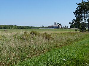
Most of Aurora is fairly flat with heavy soil, like this farm west of Gilman.
|
|

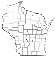
Location of Aurora, Taylor County, Wisconsin
|
|
| Country | |
| State | |
| County | Taylor |
| Area | |
| • Total | 34.2 sq mi (88.6 km2) |
| • Land | 34.2 sq mi (88.6 km2) |
| • Water | 0.0 sq mi (0.0 km2) |
| Elevation | 1,211 ft (369 m) |
| Population
(2000)
|
|
| • Total | 386 |
| • Density | 11.3/sq mi (4.4/km2) |
| Time zone | UTC-6 (Central (CST)) |
| • Summer (DST) | UTC-5 (CDT) |
| Area codes | 715 & 534 |
| FIPS code | 55-03900 |
| GNIS feature ID | 1582735 |
| PLSS township | T31N R4W, roughly |
Aurora is a town in Taylor County, Wisconsin, United States. In the year 2000, about 386 people lived there.
Contents
Geography of Aurora
Aurora is a town that covers about 34.2 square miles (88.6 km2). All of this area is land, meaning there are no large lakes or rivers within its borders.
History of Aurora
Early Surveys and Land Description
In the summer of 1847, a team from the U.S. government came to survey the land that is now Aurora. They measured out a six-mile (10 km) square area. Later, in December 1854, another team marked all the corners of the land sections. They walked through forests and swamps, using chains and compasses to measure everything.
After their work, the surveyor described the area. He noted that the land had some swamps that were not good for farming. The Yellow River flowed through the town with a gentle current. The soil was mostly "second rate," meaning it was okay but not the best for growing crops. The area was covered with trees like hemlock, birch, elm, and sugar maple. Many small streams also flowed through the town. At that time, there were no buildings or farms in the area.
Winter Roads and Logging
By 1880, a "winter road" was shown on maps. This road came from Chippewa County and followed the Yellow River. It stretched through the wild land all the way to what is now Westboro. This road was used to bring supplies to logging camps during the winter. Loggers would cut down valuable white pine trees. In the spring, they would float the logs down the Yellow River in what were called log drives.
First Settlers and Roads
An 1888 map shows the first settlers arriving in Aurora. A wagon road, which is now Polley Lane, went about a mile and a half into the township. Around ten settlers had built their homes along this road. There was also a small rural school at the end of the road. Large companies like Chippewa Lumber and Boom Co. owned most of the land.
By 1900, there were still about ten homesteads (family farms) in the southwest part of the township near the river. Many of these families had Scandinavian names. The road had been extended a few more miles, turning into what is now River Road. Most of the land was still owned by lumber companies, with very few settlers in other parts of the township.
Railroads and Growth
Between 1902 and 1903, the Stanley, Merrill and Phillips Railway built a railroad line on the east side of Aurora. This led to the creation of a station at Gilman. Around 1905, another company, J.S. Owen Company, built a railway line for the Wisconsin Central. This line went northwest across the town towards Ladysmith and Superior. Today, this line is part of the Canadian National railway.
By 1911, maps showed the railroads were fully in place. The road that became Polley Lane now stretched across the entire six-mile width of the town. River Road also reached across the river to the southern edge of the town. A road that would become Highway 64 went west out of Gilman. There was also a branch heading north towards Hannibal. The group of settlers in the southwest corner had grown, and a schoolhouse was located where Polley Lane and River Road met. A few settlers also lived on the east side, outside Gilman. Lumber companies still owned most of the land, but more settlers were starting to farm.
Population of Aurora
In the year 2000, Aurora had 386 people living in 134 households. Most of the households (108) were families. The town had about 11.3 people per square mile (4.4/km2).
Most of the people living in Aurora were White (98.19%). A small number were Native American or Asian, or from two or more races.
About 37.3% of the households had children under 18 living with them. Most households (71.6%) were married couples living together. The average household had 2.88 people, and the average family had 3.25 people.
The population was spread out by age. About 30.1% were under 18 years old. About 14.2% were 65 years or older. The average age of people in Aurora was 37 years.
See also
 In Spanish: Aurora (condado de Taylor, Wisconsin) para niños
 | May Edward Chinn |
 | Rebecca Cole |
 | Alexa Canady |
 | Dorothy Lavinia Brown |

