Avery, Texas facts for kids
Quick facts for kids
Avery, Texas
|
|
|---|---|

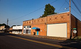
Downtown Avery
|
|
| Country | United States |
| State | Texas |
| County | Red River |
| Area | |
| • Total | 0.97 sq mi (2.52 km2) |
| • Land | 0.95 sq mi (2.46 km2) |
| • Water | 0.03 sq mi (0.06 km2) |
| Elevation | 466 ft (142 m) |
| Population
(2020)
|
|
| • Total | 421 |
| • Density | 434.0/sq mi (167.1/km2) |
| Time zone | UTC-6 (Central (CST)) |
| • Summer (DST) | UTC-5 (CDT) |
| ZIP code |
75554
|
| Area code(s) | 903, 430 |
| FIPS code | 48-05072 |
| GNIS feature ID | 2411656 |
Avery is a small town in Red River County, located in the state of Texas in the United States. In 2020, about 421 people lived there. For many years, from the 1920s to the early 1960s, Avery was famous for growing and shipping lots of tomatoes! It was one of the biggest tomato producers in northeastern Texas.
History of Avery
The town of Avery was started in the 1870s. It is located on U.S. Highway 82, about sixteen miles southeast of Clarksville. When the Texas and Pacific railroad was being built through the county in the 1870s, the railroad managers planned a station at this spot. They first named it Douglass.
At first, not many people lived in the area. A newspaper reporter visiting in 1881 found families living in tents. Later that year, a general store opened, and a post office was set up. The town's name was then changed to Isaca.
In 1902, the name was changed again to Avery. This new name honored Ed Avery, who was the first agent for the railway station.
- In 1884, about 30 people lived in Avery.
- By 1896, the population grew to 48.
- By 1900, Avery had three churches, a school, and 176 residents.
During the early 1900s, processing cotton was an important local business. By 1914, the town had two banks and its own weekly newspaper called the Avery News. The population was estimated at 500 people.
The town's population reached its highest point in the late 1920s, with about 800 residents. After that, it dropped to 300 in the early 1930s. Avery officially became a town before the 1940 census, when it had 477 residents. The population has stayed fairly steady since then. In 1990, there were 430 people, and by 2000, it increased to 462.
Geography of Avery
Avery is located in eastern Red River County. According to the United States Census Bureau, the town covers a total area of about 1.0 square mile (2.6 km2). Most of this area, about 0.9 square miles (2.3 km2), is land. A small part, about 0.04 square miles (0.10 km2), is water.
Population Information
| Historical population | |||
|---|---|---|---|
| Census | Pop. | %± | |
| 1940 | 477 | — | |
| 1950 | 442 | −7.3% | |
| 1960 | 343 | −22.4% | |
| 1970 | 491 | 43.1% | |
| 1980 | 520 | 5.9% | |
| 1990 | 430 | −17.3% | |
| 2000 | 462 | 7.4% | |
| 2010 | 482 | 4.3% | |
| 2020 | 421 | −12.7% | |
| U.S. Decennial Census | |||
As of the census in 2000, there were 462 people living in Avery. These people lived in 210 households, with 136 of them being families. The average number of people in each household was 2.20, and the average family size was 2.75.
The population was spread out by age:
- 22.7% were under 18 years old.
- 8.9% were between 18 and 24 years old.
- 22.7% were between 25 and 44 years old.
- 25.1% were between 45 and 64 years old.
- 20.6% were 65 years of age or older.
The average age of people in the town was 43 years.
See also
 In Spanish: Avery (Texas) para niños

