
Ayalon Highway facts for kids
Quick facts for kids
|
|
|---|---|
| נתיבי איילון Netivei Ayalon |
|
| Ayalon Highway | |
| Lua error in Module:Infobox_road/map at line 15: attempt to index field 'wikibase' (a nil value). | |
| Route information | |
| Length | 29 km (18 mi) |
| Major junctions | |
| From | Rishon LeZion (Holot Interchange) |
|
|
| North end | Herzliya (Begin Interchange) |
| Location | |
| Major cities: | Holon, Herzliya, Bat Yam, Tel Aviv, Givatayim, Ramat Gan |
| Highway system | |
| Roads in Israel Highways |
|


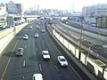
The Ayalon Highway (Hebrew: נתיבי איילון, pronounced: "Netivei Ayalon", which means "Ayalon Routes") is a super important road system in the Tel Aviv Metropolitan Area in Israel. Think of it as the main street for the entire Tel Aviv area! The most famous part of this system is Highway 20, which goes right through the heart of Tel Aviv. This highway helps millions of people travel every day, making it one of the busiest roads in the country.
Contents
The Ayalon Highway: Tel Aviv's Lifeline
The Ayalon Highway is much more than just a road. It's a vital transportation system that connects many cities around Tel Aviv. It helps people get to work, school, and other places quickly. Without it, traffic in the area would be much worse!
What is the Ayalon Highway?
Highway 20, the main part of the Ayalon Highway, is about 29 kilometers (around 18 miles) long. It stretches from HaMa'apilim Interchange near Kfar Shmaryahu, Herzliya, and Ramat HaSharon in the north. It goes all the way south to Holot Interchange in Gan Sorek. Along its path, it passes through big cities like Bat Yam, Holon, and Rishon LeZion. It also connects with other major roads, like Highway 4.
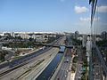
A Road and a Railway
One of the coolest things about the Ayalon Highway is that a busy railway line runs right alongside it. This means you can often see cars speeding by on one side and trains zooming past on the other! There's even a major train station, HaShalom railway station, located right next to the highway in central Tel Aviv. This unique setup helps many people choose to travel by train instead of car, which can help reduce traffic jams.
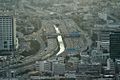
The Ayalon River Connection
In the middle of Tel Aviv, the Ayalon Highway passes by a special canal. This canal is part of the Ayalon River. The river itself is mostly dry for much of the year, but the canal helps manage water flow, especially during rainy seasons. So, as you drive or ride the train, you're also traveling alongside a piece of nature that's been adapted to fit into the busy city landscape.
Images for kids
-
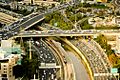
Arlozorov Interchange
-
La Guardia Interchange
-
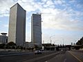
Near HaShalom Interchange
-

Near Rokach Interchange
-
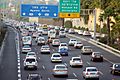
Heavy Afternoon Traffic
-
Near HaShalom railway station
-
North of Arlozorov Interchange


