
Highway 4 (Israel) facts for kids
| כביש תל אביב - אשדוד Kvish Tel Aviv–Ashdod כביש גהה Kvish Geha כביש חיפה - תל אביב הישן Kvish Haifa–Tel Aviv HaYashan |
|
| Lua error in Module:Infobox_road/map at line 15: attempt to index field 'wikibase' (a nil value). | |
Quick facts for kids Route information |
|
|---|---|
| Part of |
|
| Length | 205 km (127 mi) |
| Major junctions | |
| South end | Erez Border Crossing with Gaza (Hevel Azzah Junction) |
|
|
| North end | Rosh HaNikra Border Crossing with Lebanon |
| Location | |
| Major cities: | Ashkelon, Ashdod, Yavne, Rishon LeZion, Holon, Tel Aviv, Ramat Gan, Giv'atayim, Bnei Brak, Petah Tikva, Ramat Hasharon, Hod HaSharon, Kfar Saba, Ra'anana, Netanya, Hadera, Pardes Hanna-Karkur, Zikhron Ya'akov, Tirat Carmel, Haifa, The Kerayot, Acre, Nahariya |
| Highway system | |
| Roads in Israel Highways |
|
Highway 4, also known as Geha Road, is a very important road in Israel. It stretches all the way along the country's coast, from the border with Lebanon in the north to the border with the Gaza Strip in the south. This highway helps people travel easily between many major cities and towns. It is one of Israel's longest and busiest roads.
Contents
What is Highway 4?
Highway 4 is a major road that connects different parts of Israel. It is a "dual highway," which means it has two separate directions of traffic. Each direction has multiple lanes, making it easier for many cars to travel at once. This type of road is designed for faster and smoother journeys.
Where Does it Go?
This highway runs for about 205 kilometers (about 127 miles). It starts in the very north of Israel, at the Rosh HaNikra border crossing with Lebanon. From there, it travels south, following the beautiful Mediterranean Sea coastline. It ends at the Erez Border Crossing, which is near the Gaza Strip.
Cities Along the Way
Highway 4 passes through or near many important Israeli cities. As you travel south, you would see cities like Nahariya, Acre, and Haifa in the north. Further south, it connects to Hadera, Netanya, and Kfar Saba.
It also goes through the busy central area of Israel. Here, it links cities like Petah Tikva, Bnei Brak, Ramat Gan, Tel Aviv, and Holon. Even further south, it reaches Rishon LeZion, Yavne, Ashdod, and Ashkelon. This makes it a vital route for people living and working in these areas.
Important Junctions
Along its long path, Highway 4 connects with many other roads and highways. These connection points are called junctions or interchanges. They help drivers switch from Highway 4 to other roads to reach their final destinations. Some of the well-known junctions include the Ashdod Interchange, Holot Interchange, and HaSharon Junction. These junctions help manage the flow of traffic across the country.
Images for kids
-
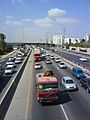
Heavy morning traffic at Bar Ilan Interchange
-
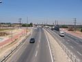
Abba Hillel Silver Junction


