
Gaza Strip facts for kids
Quick facts for kids
Gaza Strip
قِطَاعُ غَزَّةَ
Qiṭāʿu Ġazzah |
|
|---|---|
 Palestinian flag
|
|
 |
|
| Status |
|
| Capital and largest city
|
Gaza City 31°31′N 34°27′E / 31.517°N 34.450°E |
| Official languages | Arabic |
| Ethnic groups | Palestinian |
| Demonym(s) | Gazan Palestinian |
| Area | |
|
• Total
|
365 km2 (141 sq mi) |
| Population | |
|
• 2020 estimate
|
2,047,969 |
|
• Density
|
5,046/km2 (13,069.1/sq mi) |
| Currency |
|
| Time zone | UTC+2 (Palestine Standard Time) |
|
• Summer (DST)
|
UTC+3 (Palestine Summer Time) |
| Calling code | +970 |
| ISO 3166 code | PS |
|
|
The Gaza Strip (Arabic: قِطَاعُ غَزَّةَ Qiṭāʿu Ġazzah), often called simply Gaza, is a self-governing Palestinian area. It is located on the eastern coast of the Mediterranean Sea.
Gaza shares a border with Egypt to the southwest, which is about 11 kilometers (7 miles) long. To the east and north, it borders Israel for about 51 kilometers (32 miles). The Gaza Strip and the West Bank are both claimed by the State of Palestine.
These two areas, Gaza and the West Bank, are separated by Israeli land. Both were meant to be governed by the Palestinian Authority. However, since 2007, the Gaza Strip has been governed by Hamas. Hamas is a Palestinian group that won elections in 2006.
After Hamas took control, the Gaza Strip faced an international economic and political boycott. This means many countries stopped trading with or supporting the area.
The Gaza Strip is about 41 kilometers (25 miles) long. It is between 6 and 12 kilometers (4 to 7 miles) wide. Its total area is about 365 square kilometers (141 square miles). With around 1.85 million people, Gaza is one of the most crowded places in the world.
A special area called a "buffer zone" is kept by Israel inside the Strip. This means a lot of land cannot be used by Palestinians in Gaza. The population of Gaza grows quickly, making it feel even more crowded.
In 2012, the United Nations warned that Gaza might not be a "liveable place" by 2020. By 2020, Gaza faced shortages of water, medicine, and electricity. This situation became even harder during the coronavirus crisis. Many groups have asked Israel to end its blockade on Gaza. The UN also said that Gaza's economy was close to collapsing.
Because of border closures by Israel and Egypt, people cannot easily leave or enter Gaza. It is also hard to import or export goods freely. Most people in Gaza are Sunni Muslims.
Even though Israel removed its settlements from Gaza in 2005, many still see it as occupied. This is because Israel controls Gaza's air and sea. It also controls most of the land crossings. Israel can send its military into Gaza whenever it wants. It also keeps a no-go buffer zone inside Gaza. Gaza relies on Israel for water, electricity, and phone services.
When Hamas won the 2006 elections, another political group, Fatah, did not want to work with them. A short-lived agreement was made, but it failed. After this, Fatah formed a government in the West Bank. Hamas then formed its own government in Gaza.
More economic restrictions were put on Hamas by Israel and other groups. There were also disagreements between the Palestinian groups in Gaza. Hamas won these disagreements and has been the main governing power in Gaza ever since.
Contents
Geography and Climate
The Gaza Strip is located in the Middle East. It has a 51-kilometer (32-mile) border with Israel. It also has an 11-kilometer (7-mile) border with Egypt, near the city of Rafah.
Khan Yunis is a city located about 7 kilometers (4 miles) northeast of Rafah. Several towns near Deir el-Balah are along the coast between it and Gaza City. Beit Lahia and Beit Hanoun are north and northeast of Gaza City. The coast along the Mediterranean Sea is about 40 kilometers (25 miles) long.
Weather in Gaza
The Gaza Strip has a hot, semi-dry climate. Winters are warm and most of the rain falls then. Summers are dry and hot. Even though it is dry, the air usually feels humid all year. About 300 to 400 millimeters (12 to 16 inches) of rain falls each year. Almost all of this rain comes between November and February.
The land is mostly flat or gently rolling. There are sand dunes near the coast. The highest point is Abu 'Awdah, which is 105 meters (344 feet) above sea level.
Environmental Challenges
Gaza faces several environmental problems. These include:
- Desertification: land becoming like a desert.
- Salination of fresh water: fresh water becoming salty.
- Problems with sewage treatment.
- Water-borne diseases: illnesses spread by water.
- Soil degradation: soil becoming less healthy.
- Running out of and polluting underground water.
Natural Resources
Gaza has arable land, which means land good for farming. About one-third of the Strip has irrigation systems to water crops. Recently, natural gas was found off the coast.
The Gaza Strip mostly gets its water from Wadi Gaza. This stream also supplies water to Israel. Gaza's natural gas reserves are about 32 kilometers (20 miles) from the coast. They are estimated to hold 35 billion cubic meters of gas.
People of Gaza
In 2010, about 1.6 million Palestinians lived in the Gaza Strip. Almost 1 million of these people were refugees registered with the UN. Most Palestinians in Gaza are descendants of refugees. These refugees left their homes during the 1948 Arab–Israeli War.
The number of people in Gaza has kept growing. This is partly because families often have many children. In 1991, women had an average of 8.3 children. By 2013, this number fell to 4.4 children per woman. This is still one of the highest rates in the world.
Because of the high birth rate, a large part of Gaza's population is made up of children. In 2014, 43.5% of the people were 14 years old or younger. The average age in Gaza was 18, while the world average was 28.
Most people living in the Gaza Strip are Sunni Muslims. There are also about 2,000 to 3,000 Arab Christians. This means about 99.8% of the population is Sunni Muslim and 0.2% is Christian.
Education

In 2010, almost all young people in Gaza could read and write. Less than 1% of youth were unable to read. According to UNRWA, there are 640 schools in Gaza. These include 383 government schools, 221 UNRWA schools, and 36 private schools. These schools teach a total of 441,452 students.
In 2010, a private school in central Gaza started a special math program. This program helps students develop their mental math skills. It was first created in Malaysia in 1993.
By 2012, there were five universities in the Gaza Strip. Eight new schools were also being built. By 2018, the number of universities had grown to nine.
The Community College of Applied Science and Technology (CCAST) opened in 1998 in Gaza City. In 2007, it became the University College of Applied Sciences (UCAS). In 2010, this college had 6,000 students. It offered over 40 different study programs.
Culture and Sports

Art in Gaza
The Gaza Strip has been an important place for Palestinian art since the mid-1900s. Many famous artists come from Gaza. These include painters like Ismail Ashour and Shafiq Redwan. There are also media artists such as Taysir Batniji and Laila al Shawa.
New artists are also active in art groups. These groups often hold art shows and events for everyone to enjoy.
Sports and Athletics
In 2010, Gaza opened its first Olympic-size swimming pool. It is located at the As-Sadaka club. The swimming team from As-Sadaka has won many gold and silver medals in Palestinian swimming competitions.
Transportation and Communication

The Oslo Accords gave Israel control over Gaza's air and sea space. This means that leaving or entering Gaza usually needs help from either Egypt or Israel.
Roads in Gaza
Salah al-Din Road is the main highway in the Gaza Strip. It is about 45 kilometers (28 miles) long. It runs the entire length of Gaza, from the Rafah Border Crossing in the south to the Erez Crossing in the north. The road is named after a famous general from the 12th century, Salah al-Din.
Sea Travel
The Port of Gaza has been an important port for a very long time. There were plans to make the port bigger. However, it has been under a blockade since 2006. Both the Israeli Navy and Egypt enforce this blockade.
The blockade has made many parts of life in Gaza difficult. It especially limits how people can move and how goods can be traded. Exports are the most affected. Building and fixing things in Gaza is also harder because of these restrictions.
Air Travel
The Yasser Arafat International Airport opened in 1998. It was closed by Israel in October 2000. Its radar station and control tower were destroyed in 2001. The runway was also damaged in 2002. The only other runway in Gaza is no longer used. Israel's air force can also limit flights over Gaza.
Phone and Internet
The Gaza Strip has basic landline phone service. There are also many mobile phone services. These are provided by PalTel (Jawwal) and Israeli companies. Gaza has four internet providers. They offer both high-speed internet (ADSL) and dial-up services.
TV and Radio
In 2004, most homes in Gaza had a radio and a TV. About 20% of homes had a computer. People in Gaza can watch free satellite TV programs. They can also watch TV from Palestinian and Israeli broadcasters.
Notable People
- Al-Shafiʽi
- Mohammed Assaf
- Dorotheus of Gaza
- Hilarion
- Nathan of Gaza
- Porphyry of Gaza
- Procopius
- Sozomen
Images for kids
-
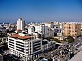
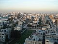
Gaza City skyline, 2007.
-
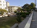
Downtown Gaza, 2012.
-
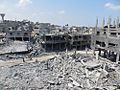
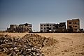
Beit Hanoun region of Gaza in August 2014, after Israeli bombardments.
-
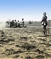
British artillery battery in front of Gaza, 1917
-
View of Gaza during the 2000s.
-
The Al Deira Hotel on the Gaza coast, 2009
-
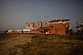
Buildings damaged during Operation "Cast Lead".
-
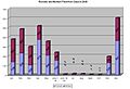
Monthly rocket and mortar hits in Israel, 2008.
-
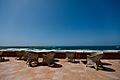
Sea-view from the Al Deira Hotel on the Gaza coast
-
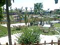
A resort in the Gaza Strip built on the location of the former Israeli settlement of Netzarim
-
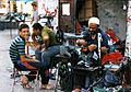
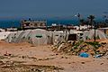
Backyard industry
-
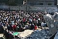
Muslim worshippers in Gaza
-
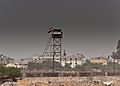
Watchtower on the border between Rafah and Egypt.
-
Tent camp, April 2009, after Cast Lead.


See also
 In Spanish: Franja de Gaza para niños
