
Béjaïa Province facts for kids
Quick facts for kids
Béjaïa Province
ولاية بجاية
|
|
|---|---|

Map of Algeria highlighting Béjaïa
|
|
| Country | |
| Capital | Béjaïa |
| Area | |
| • Total | 3,268 km2 (1,262 sq mi) |
| Population
(2008)
|
|
| • Total | 915,835 |
| • Density | 280.24/km2 (725.83/sq mi) |
| Time zone | UTC+01 (CET) |
| Area Code | +213 (0) 34 |
| ISO 3166 code | DZ-06 |
| Districts | 19 |
| Municipalities | 52 |
Béjaïa Province is a special area in Algeria, a country in North Africa. It's like a state or region. The main city and capital of this province is also called Béjaïa.
This province is a really interesting place! It's home to Gouraya National Park, which is a beautiful natural area. In this park, you can find the Barbary Macaque, a type of monkey that is an endangered animal. This means there aren't many of them left in the world, so it's important to protect them.
Exploring Béjaïa Province
Béjaïa Province covers an area of about 3,268 square kilometers. That's roughly the size of a small country! In 2008, almost a million people lived here, with a population of 915,835.
The province is divided into smaller parts to help manage everything. It has 19 main areas called districts. Within these districts, there are 52 even smaller areas known as communes or municipalities. Think of them like towns or local communities.
Districts of Béjaïa
Here are the 19 districts that make up Béjaïa Province:
- Adekar
- Akbou
- Amizour
- Aokas
- Barbacha
- Béjaïa
- Béni Maouche
- Chemini
- Darguina
- El Kseur
- Ifri-Ouzellaguen
- Ighil Ali
- Kherrata
- Seddouk
- Sidi Aïch
- Souk El Tenine
- Tazmalt
- Tichy
- Timezrit
Images for kids
-
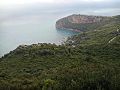
Coast of Bejaia Province
.jpg)
See also
 In Spanish: Provincia de Bugía para niños
