Baker River (New Brunswick) facts for kids
Quick facts for kids Baker River |
|
|---|---|

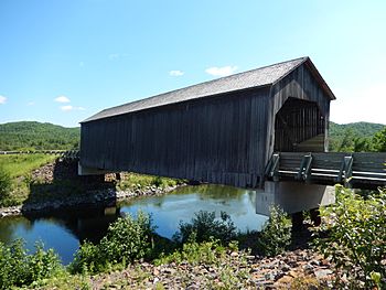
A bridge across Baker River
|
|
| Country | Canada |
| Province | New Brunswick |
| County of New Brunswick | Madawaska County |
| Physical characteristics | |
| Main source | Baker Lake (New Brunswick) 201 m (659 ft) 47°21′46″N 69°41′01″W / 47.36278°N 69.68361°W |
| River mouth | Saint John River (Bay of Fundy) 147 m (482 ft) 47°18′01″N 68°30′32″W / 47.30028°N 68.50889°W |
| Length | 26.3 km (16.3 mi) |
| Basin features | |
| Tributaries |
|
The Baker River is a waterway in New Brunswick, Canada. It's a smaller river that flows into the larger Saint John River (Bay of Fundy). You can find it in Madawaska County, which is in the northwest part of New Brunswick.
Contents
Where the Baker River Starts and Flows
The Baker River begins its journey in a place called Baker Lake (New Brunswick). This lake is about 7.9 kilometers long.
Baker Lake Details
- A small part of Baker Lake reaches into Quebec, near a town called Saint-Jean-de-la-Lande, Quebec.
- The lake has an island in its middle. It's about 1.2 kilometers long.
- There are many chalets, or small cabins, around the lake.
- Water flows into Baker Lake from Kitchen Creek, which comes from the west, near the Quebec border.
The River's Path
The Baker River flows for about 26.3 kilometers from Baker Lake. Here's how it travels:
- First, it goes northeast for 2.8 kilometers. Here, it meets "Jerry's stream."
- Then, it flows southeast and northeast for 4.6 kilometers, meeting "Ouellette's stream."
- It continues northeast for 1.3 kilometers, joining with the North Baker River (New Brunswick).
- Next, it winds southeast for 5.4 kilometers, where it meets "Great Reed Creek."
- It flows southeast for another 4.2 kilometers, picking up water from Sisson Brook, until it reaches a highway bridge.
- Finally, it meanders east for 8.5 kilometers (or 4.8 kilometers in a straight line) until it joins the Saint John River.
Where it Ends
The Baker River flows into the Saint John River (Bay of Fundy) on its north shore, near a place called Baker Brook. There's also an island called Baker Island nearby. In this area, the Saint John River forms the border between Canada (New Brunswick) and the United States (Maine).
After the Baker River joins it, the Saint John River continues southeast through New Brunswick. It eventually reaches the northern shore of the Bay of Fundy, which opens up to the Atlantic Ocean.
What's in a Name?
The name "Baker" comes from an old English family name.

