Balls Island facts for kids
|
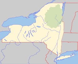
Location of Balls Island within New York
|
|
| Geography | |
|---|---|
| Location | Susquehanna River |
| Coordinates | 42°14′50″N 75°29′17″W / 42.24722°N 75.48806°W |
| Highest elevation | 971 ft (296 m) |
| Administration | |
|
|
|
| State | New York |
| County | Chenango |
| Village | Middle Bridge |
Balls Island is a small piece of land completely surrounded by water. It is found in the Susquehanna River, near a place called Middle Bridge, New York. This island is located in the state of New York, in the United States.
Contents
Discover Balls Island
Balls Island is a natural landform in the Susquehanna River. An island is a piece of land that has water all around it. This island is part of the beautiful landscape of Chenango County, New York.
Where is Balls Island Located?
Balls Island is situated in the Susquehanna River. This river is one of the longest rivers on the East Coast of the United States. The island is specifically located near the village of Middle Bridge, New York.
- State: New York
- County: Chenango County
- Nearby Village: Middle Bridge
You can find its exact spot on a map using its coordinates: 42 degrees, 14 minutes, 50 seconds North, and 75 degrees, 29 minutes, 17 seconds West.
What is the Elevation of Balls Island?
The elevation of Balls Island is about 971 feet above sea level. Elevation tells us how high a place is compared to the ocean's surface. This measurement helps us understand the island's height within the river valley.
The Susquehanna River
The Susquehanna River is very important to the areas it flows through. It starts in New York and flows through Pennsylvania and Maryland. Finally, it empties into the Chesapeake Bay. The river is home to many islands, including Balls Island. These islands are often formed by the river's flow over many years.


