
Ballyroan, Dublin facts for kids
Quick facts for kids
Ballyroan
Baile Uí Ruáin
|
|
|---|---|
|
Suburb
|
|

Ballyroan
|
|

Ballyroan
Location in Ireland
|
|
| Country | Ireland |
| Province | Leinster |
| County | County Dublin |
| Elevation | 61 m (200 ft) |
| Time zone | UTC+0 (WET) |
| • Summer (DST) | UTC-1 (IST (WEST)) |
Ballyroan (Irish: Baile Uí Ruáin, meaning O'Rowan's town) is a lovely suburban area in Rathfarnham, County Dublin, Ireland. It's located at the base of the Dublin mountains. Ballyroan is close to other areas like Ballyboden, Butterfield, Knocklyon, Old Orchard, and Scholarstown.
This area is a modern suburb that has grown over time. It includes parts of what was once known as a "townland." A townland is a very old way of dividing land in Ireland.
Contents
What You'll Find in Ballyroan
The heart of Ballyroan is a busy place. Here you can find the Ballyroan Community & Youth Centre. This is a great spot for local activities and events.
Shopping and Services
You'll also find the Rosemount Shopping Centre in Ballyroan. This is where people go for their everyday needs. There are shops and services for everyone.
Ballyroan Parish Church
The local parish church opened its doors in December 1967. Inside, it has two special murals. These beautiful artworks were created by a famous artist named Seán Keating.
Ballyroan Public Library
Ballyroan is home to a modern public library. The original library opened in 1986. It was closed and taken down in September 2011. A brand new, much larger library was built in its place. This new library cost €2.6 million to build. It officially opened on February 18, 2013, and is twice the size of the old one.
Education in Ballyroan
Ballyroan has good options for schooling. There are two secondary schools in the area.
Secondary Schools
- Sancta Maria College is a secondary school for students.
- Coláiste Éanna is another secondary school in Ballyroan.
Scouting
There is also a local Scout Group. Scouting is a fun way for young people to learn new skills. They also get to enjoy outdoor activities and make friends.
Getting Around Ballyroan
Ballyroan is easy to reach by public transport.
Bus Services
The area is served by the 15B bus route. This bus helps people travel to and from Ballyroan.
Images for kids
-
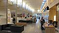
Inside the public library on Orchardstown Villas
-
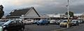
The Ballyroan Community & Youth Centre (left) and Rosemount Shopping Centre (right)
-
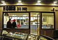
A fish and chip shop on Marian Road
-
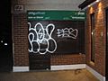
The former post office on Marian Road


